November 07
No birdmap update
(Arvo is moving in the same area)
Arvo (2CY - subadult)
-
marika.solo
- Site Admin
- Posts: 29484
- Joined: 29 Sep 2021, 09:38
Re: Arvo (2CY - subadult)
previous data 06.11 viewtopic.php?p=65130#p65130
next data 10.11 viewtopic.php?p=65161#p65161
November 08 data
Hello everyone
wintering site since 20.09
Previous data
- Last data: 06.11, Distance: 4958 km (+ 8 km)
- France: Saint-Gilles / Saint-Gilles-du-Gard - a commune in the department of Gard, and the administrative region of Occitania (southern France)
- 07.11
- NO birdmap update
NEW data
- Last data: 08.11, Distance: 4973 km (+ 15 km in 2 days)
- France: Saliers - a village in the commune of Arles, Département Bouches-du-Rhône, Region Provence-Alpes-Côte d’Azur
information and links to details, photos viewtopic.php?p=64539#p64539 and next
-
marika.solo
- Site Admin
- Posts: 29484
- Joined: 29 Sep 2021, 09:38
Re: Arvo (2CY - subadult)

Égout de Saliers:
Date de création Egout de Saliers : 30 juillet 1891 – Fossés d’écoulage : 24 novembre 1937
Date of creation for the Saliers drain: July 30, 1891 – Drainage ditches: November 24, 1937
2004 (!)
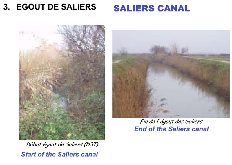
(source: https://www.parc-camargue.fr/parc-camar ... anaux3.pdf)
The rice is harvested from mid-September to the end of October. The paddy fields are drained to allow harvesters, equipped with caterpillar tracks to collect the rice, and transport it to nearby silos. ... During the rest of autumn and winter, each field is dried and levelled with the aid of a laser-guided blade as the surface must be as flat as possible. Canals and drains are repaired.
first on 19.10.2025 viewtopic.php?p=52627#p52627
------
(AI answered) The Égout de Saliers refers to a major agricultural drainage canal network located in the Camargue region, within the commune of Arles, France. In this specific region, the historic term "égout" (which usually means "sewer" in modern French) does not refer to urban wastewater, but rather to an open-sky drainage canal used to evacuate excess water from marshes and agricultural fields.
Network Characteristics
According to hydrological data from the Camargue Regional Nature Park, the network spans a linear distance of approximately 8 kilometres and is structured around three main branches:
• The Main Canal: Measuring 5,900 meters in length.
• The Roncelles Secondary Canal: Measuring 1,500 meters in length.
• The Mas de la Vigne Section: Measuring 300 meters in length.
Role and Hydraulic Management
• Collective Management: The maintenance and operation of these channels are managed by a local authorised syndical association, the ASA Égouts et Fossés Saliers Bénévent.
• Salinity Control: This network is vital for local agriculture—especially rice farming—as it flushes out highly saline water to prevent soil salinisation and waterlogging.
• Infrastructure Impact: Part of its historic route was modified during the modernisation works of the D37 departmental road.
-
marika.solo
- Site Admin
- Posts: 29484
- Joined: 29 Sep 2021, 09:38
Re: Arvo (2CY - subadult)
previous data 08.11 viewtopic.php?p=65148#p65148
next data
November 10
Hello everyone
wintering site since 20.09
Previous data
- Last data: 08.11, Distance: 4973 km (+ 15 km in 2 days)
- France: Saint-Gilles / Saint-Gilles-du-Gard - a commune in the department of Gard, and the administrative region of Occitania (southern France)
- 09.11
- NO birdmap update
NEW data
- Last data: 10.11, Distance: 4990 km (+ 17 km in 2 days)
- France: Saliers - a village in the commune of Arles, Département Bouches-du-Rhône, Region Provence-Alpes-Côte d’Azur
information and links to details, photos viewtopic.php?p=64539#p64539 and next

-
marika.solo
- Site Admin
- Posts: 29484
- Joined: 29 Sep 2021, 09:38
Re: Arvo (2CY - subadult)
to me this Arvo's area is visible on the photo below


first posted on 14.10.2025 viewtopic.php?p=52563#p52563
source: https://www.cheminsdesparcs.fr/en/trek/ ... rs-by-bike
Les marais de Saliers
... one of the last marshy islets located in agricultural zone ...
In the greater Camargue, the marais de Saliers represent one of the main zones of marshes and ponds soft or brackish. This Camargue sector fluvio-lacustrine includes a mosaic of natural habitats such as reed beds, typhids, wet meadows, saladella lawns, but also sansouïres and agricultural areas, mainly rice paddies. The cattle industry is also well represented. Les marais de Saliers formerly occupied a large part of the territory.

source: https://www.arlestourisme.com/fr/assets ... salier.pdf + https://admin.cheminsdesparcs.fr/api/en ... a-velo.pdf
first posted on 14.10.2025 viewtopic.php?p=52563#p52563
source: https://www.cheminsdesparcs.fr/en/trek/ ... rs-by-bike
Les marais de Saliers
... one of the last marshy islets located in agricultural zone ...
In the greater Camargue, the marais de Saliers represent one of the main zones of marshes and ponds soft or brackish. This Camargue sector fluvio-lacustrine includes a mosaic of natural habitats such as reed beds, typhids, wet meadows, saladella lawns, but also sansouïres and agricultural areas, mainly rice paddies. The cattle industry is also well represented. Les marais de Saliers formerly occupied a large part of the territory.
source: https://www.arlestourisme.com/fr/assets ... salier.pdf + https://admin.cheminsdesparcs.fr/api/en ... a-velo.pdf