Iksi (2025) - Pärnu County, offspring of Kergu and Kerli

Post Reply
marika.solo
Site Admin
Posts: 22443
Joined: 29 Sep 2021, 09:38

Re: Iksi (2025) - Pärnu County, offspring of Kergu and Kerli

Post by marika.solo »

previous data 13.10 viewtopic.php?p=52542#p52542 - new data 15.10 viewtopic.php?p=52578#p52578

Oktober 14
Hello everyone :-)

Previous data
- 13.10, Distance: 2157 km (+ 222 km)
- SLOVAKIA: Gemerský Jablonec Water Reservoir - Rimavská Sobota district of the Banská Bystrica Region

NEW data
travelling day
- 14.10, Distance: 2321 km (+ 161 km)
- HUNGARY: Bokros/Csongrád - a town in Csongrád County
(in southern Hungary)

Iksi continued to the south.

continuation:
Image

Image
marika.solo
Site Admin
Posts: 22443
Joined: 29 Sep 2021, 09:38

Re: Iksi (2025) - Pärnu County, offspring of Kergu and Kerli

Post by marika.solo »

Image

Iksi is out of this pic (in the area to the west)
Image
PHOTO https://maps.app.goo.gl/fo4hjtuqhdfNCjiHA - Gergely Katona - 06/2020
marika.solo
Site Admin
Posts: 22443
Joined: 29 Sep 2021, 09:38

Re: Iksi (2025) - Pärnu County, offspring of Kergu and Kerli

Post by marika.solo »

previous data 14.10 viewtopic.php?p=52558#p52558 - new data 16.10 viewtopic.php?p=52591#p52591

Oktober 15
Hello everyone :-)

Previous data
- 14.10, Distance: 2321 km (+ 161 km)
- HUNGARY: Bokros/Csongrád - a town in Csongrád County
(in southern Hungary)

NEW data
travelling day
- 15.10, Distance: 2511 km (+ 190 km)
- CROATIA (Serbia): Opatovac (Опатовац) - a village in Lovas municipality in the Vukovar-Syrmia County of eastern Croatia
(on the shore the Danube - border river)

wiki: The village is home to one of the last remaining steppe grasslands in Croatia at the section of the Vukovar Plateau.

continuation
Image
marika.solo
Site Admin
Posts: 22443
Joined: 29 Sep 2021, 09:38

Re: Iksi (2025) - Pärnu County, offspring of Kergu and Kerli

Post by marika.solo »

Image

Image

video uploaded on 23.07.2025 by Ivan Borojević
Opatovac and winter port for ships


photos booking https://www.booking.com/hotel/hr/kuca-z ... _changed=1

Opatovac and the Danube
Image
marika.solo
Site Admin
Posts: 22443
Joined: 29 Sep 2021, 09:38

Re: Iksi (2025) - Pärnu County, offspring of Kergu and Kerli

Post by marika.solo »

previous data 15.10 viewtopic.php?p=52578#p52578 - new data 17.10 viewtopic.php?p=52599#p52599

Oktober 16
Hello everyone :-)

Previous data
- 15.10, Distance: 2511 km (+ 190 km)
- CROATIA (Serbia): Opatovac (Опатовац) - a village in Lovas municipality in the Vukovar-Syrmia County of eastern Croatia
(on the shore the Danube - border river)

NO NEW data from Iksi today
marika.solo
Site Admin
Posts: 22443
Joined: 29 Sep 2021, 09:38

Re: Iksi (2025) - Pärnu County, offspring of Kergu and Kerli

Post by marika.solo »

previous data 16.10 viewtopic.php?p=52591#p52591 - new data 18.10 viewtopic.php?p=52615#p52615

Oktober 17
Hello everyone :-)

Previous data viewtopic.php?p=52578#p52578
- 15.10, Distance: 2511 km (+ 190 km)
- CROATIA (Serbia): Opatovac (Опатовац) - a village in Lovas municipality in the Vukovar-Syrmia County of eastern Croatia
(on the shore the Danube - border river)

- 16.10
- BOSNIA and HERZEGOVINA: Lisovići - a village in the municipality of Trnovo

NEW data
- 17.10, Distance: 2808 km (+ 297 in 2 days)
- Republika SRPSKA, BOSNIA and HERZEGOVINA: Fatnica (Фатница) - a village in the municipality of Bileća


Image

Image

the intermittent stream Obod and the Fatnica – Bilećko kanal (a hydroelectric and water supply canal that connects the Fatnica River to Bilećko Lake) - view on the valley and the canal https://maps.app.goo.gl/HDbSCioF45NzU6Kt6 - 08/2025 - Mihajlo Markovic

Image
marika.solo
Site Admin
Posts: 22443
Joined: 29 Sep 2021, 09:38

Re: Iksi (2025) - Pärnu County, offspring of Kergu and Kerli

Post by marika.solo »

Fatničko polje / Fatničko field

(few info only here - the whole text: https://bs-wikipedia-org.translate.goog ... r_pto=wapp)

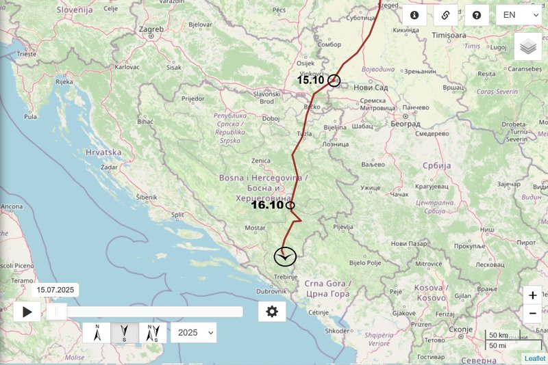
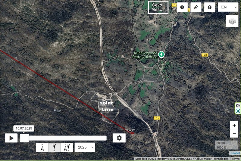
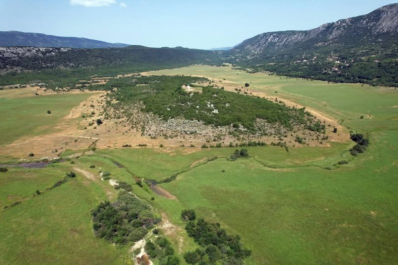
Fatničko polje is a karst field in Bosnia and Herzegovina, in the municipality of Bileća. It is located about 3 km southeast of Dabarsko polje and is a natural extension of Dabarsko polje in the southeast direction. They are separated by a small limestone ridge, which caused them to become two separate entities in terms of hydrological characteristics. It is surrounded by the mountains of Kosmatuša, Brusnik, Vranjevića, Kuk, Oblo Brdo and Gruba Glava. ..... It covers an area of ​​about 5.6 km² and is located at an altitude of 460–500 m above sea level.
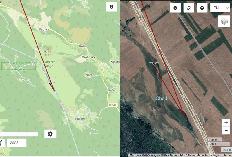
Part of the water that is lost in the Srđevići abyss in the northwestern part of the Gatačko polje , after an underground flow, appears in the Obod spring, in the eastern part of the Fatničko polje. This is also the main water inflow to the field, given that its orographic basin is relatively small, with an area of ​​40 km2. The Zvonuša spring is also nearby.
...
The settlements in the field are: Fatnica, Kalac, Orahovice, Bačevice, Divin, Narat, Pađeni. To the south are limestone hills behind which are the settlements of Kukričje and Kuti . The population is mainly engaged in livestock breeding and agriculture.

Fatničko polje i potok Obod /Fatničko field and Obod stream (uploaded on 01.07.2024)
Image
FB Mikološko udruženje Mycobh - Mycological Society Mycobh's https://www.facebook.com/mycobh/posts/f ... 033727120/
marika.solo
Site Admin
Posts: 22443
Joined: 29 Sep 2021, 09:38

Re: Iksi (2025) - Pärnu County, offspring of Kergu and Kerli

Post by marika.solo »

previous data 17.10 viewtopic.php?p=52599#p52599 - new data 19.10

Oktober 18
Hello everyone :-)

Previous data
- 17.10, Distance: 2808 km (+ 297 km in 2 days)
- Republika SRPSKA, BOSNIA and HERZEGOVINA: Fatnica (Фатница) - a village in the municipality of Bileća

NEW data
- 18.10, Distance: km (+ km )
-
Post Reply

Return to “Estonia”