BS with transmitter from nest in RS Makov (to 31.12.2021)

Re: BS with transmitter from CZECHIA
-
marika.solo
- Site Admin
- Posts: 27553
- Joined: 29 Sep 2021, 09:38
Re: BS with transmitter from CZECHIA
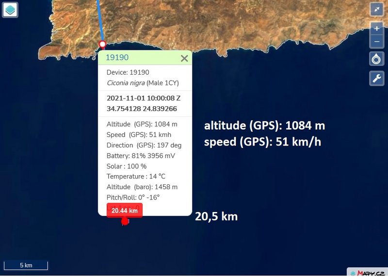
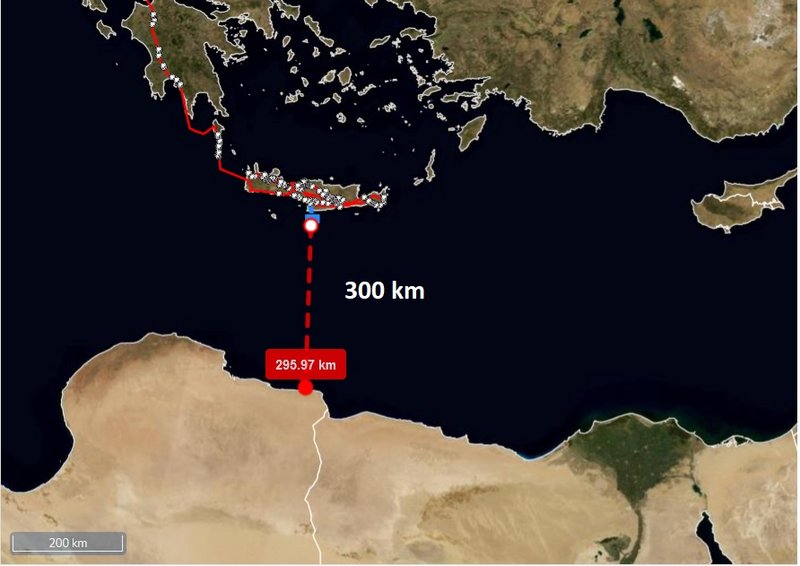
marika.solo wrote: ↑01 Nov 2021, 11:15BLUE sent data, stork is above the open sea, direction to the south finger crossed very, very much
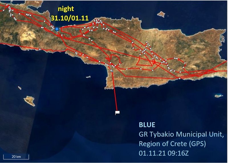
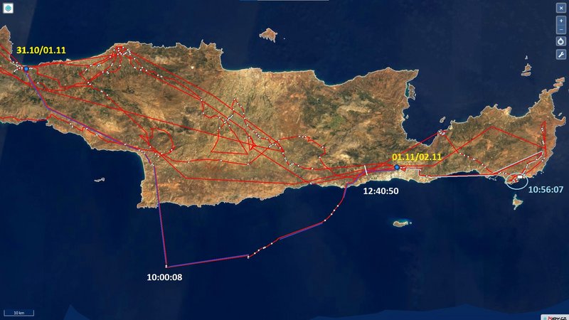
DISCOVERING CRETE on 01.11 to 10h
BLUE is back on the island (Crete)
BLUE flew in the morning to the open sea to the south (approx. 20 km at 10h) .... but returned to the mainland (and did well, the weather changed)
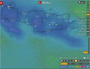
wind (click for big)
-
marika.solo
- Site Admin
- Posts: 27553
- Joined: 29 Sep 2021, 09:38
Re: BS with transmitter from CZECHIA
BLUE continuation
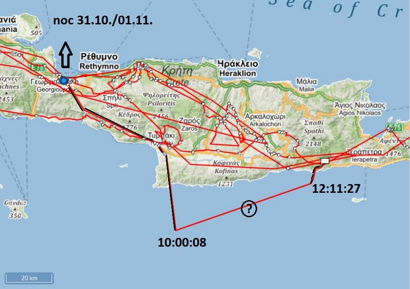
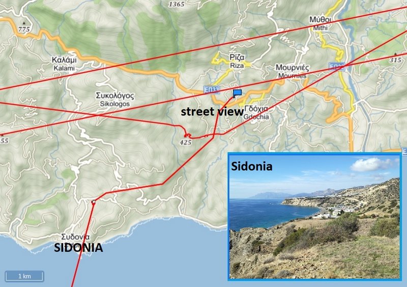
PHOTO https://goo.gl/maps/cgLNC2Yry8GVuRQN7 image capture Nov 2018
STREET VIEW there BLUE crossed the main-road https://goo.gl/maps/1sKbNq22PBKLTBrm7
(view back to the sea - nearby to his localisation there https://goo.gl/maps/ei8qi82bpppAXGBo6)
PHOTO https://goo.gl/maps/cgLNC2Yry8GVuRQN7 image capture Nov 2018
STREET VIEW there BLUE crossed the main-road https://goo.gl/maps/1sKbNq22PBKLTBrm7
(view back to the sea - nearby to his localisation there https://goo.gl/maps/ei8qi82bpppAXGBo6)
-
marika.solo
- Site Admin
- Posts: 27553
- Joined: 29 Sep 2021, 09:38
Re: BS with transmitter from CZECHIA
BLUE
answer from the birdwatcher (photographer who took Blue) Nikos Samaritakis from Crete (PM) - overwintering black storks
Well it's not common to overwinter. But has happened before.
Most will fly around Crete well into December and then move on. Rarely they will overwinter around reservoirs and river valleys
-
marika.solo
- Site Admin
- Posts: 27553
- Joined: 29 Sep 2021, 09:38
Re: BS with transmitter from CZECHIA
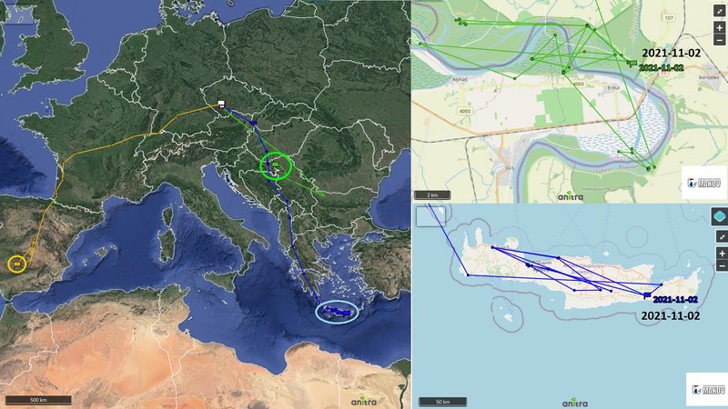
November 02
Hello everyone
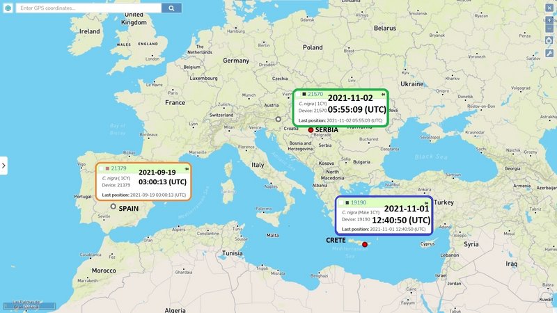
GREEN: explored the nearby new areas (near the bike route not far from the island Donji Prut)
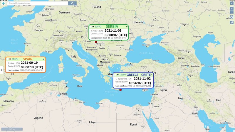
BLUE: SE Crete, Greece - NW from Gdochia, in fly (next data session again in midday)
ORANGE: still no new data
the non-public Anitra map and the simplified public Makov map (night resting places) ( https://www.makov.cz/clanky/telemetrie-makov-24.html)
Hello everyone
GREEN: explored the nearby new areas (near the bike route not far from the island Donji Prut)
BLUE: SE Crete, Greece - NW from Gdochia, in fly (next data session again in midday)
ORANGE: still no new data
the non-public Anitra map and the simplified public Makov map (night resting places) ( https://www.makov.cz/clanky/telemetrie-makov-24.html)
-
marika.solo
- Site Admin
- Posts: 27553
- Joined: 29 Sep 2021, 09:38
Re: BS with transmitter from CZECHIA
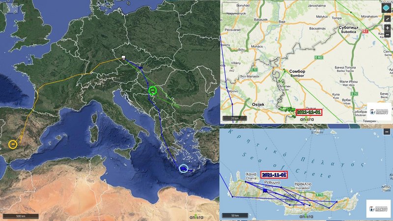
GREEN public map: https://www.makov.cz/clanky/telemetrie-makov-24.html
(last post viewtopic.php?p=464#p464)
GREEN stayed yesterday in one of its favourite areas east from the island Donji Prut (along the cycle path) and again searched for food on the nearby area to the south-east - not far from the Luka Dunav (port operating company in Bogojevo, Serbia)
This port on the Danube near Bogojevo, in the municipality of Odzaci, will be expanded, because the traffic of goods on inland waterways is expected to increase in the coming years. (the project https://www.mgsi.gov.rs/sites/default/f ... ojekat.pdf)
This place is out from the Special nature reserve Gornje Podunavlje.
from the new feeding place to usually night-resting area and again back in the early morning
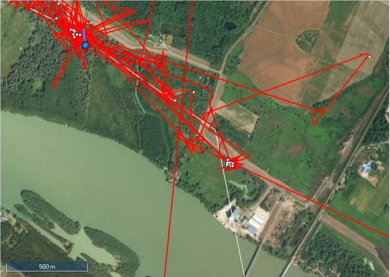
the new feeding area (already yesterday - stork spent the day again there)
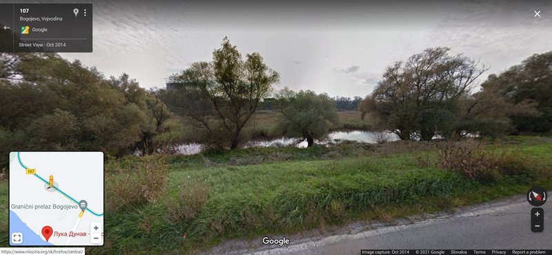
STREET VIEW https://goo.gl/maps/tEFjQ673ZPA9rnwh9 image capture Oct 2014
"current" view on the port area
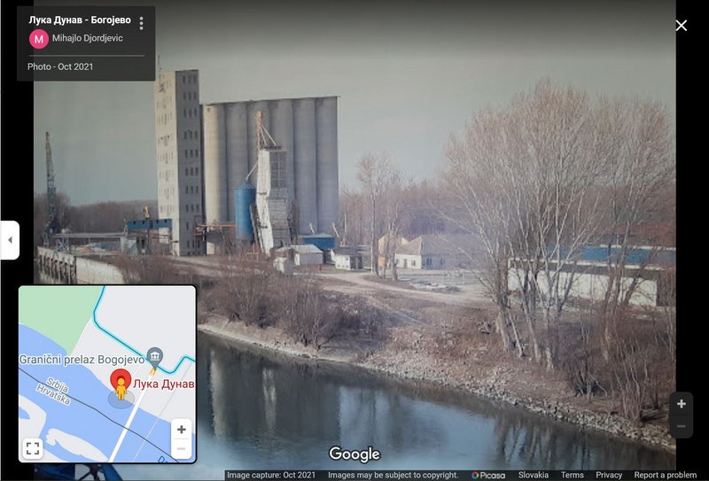
PHOTO https://goo.gl/maps/bLhJQdoXGDdvDL4u9 image capture Oct 2021
(last post viewtopic.php?p=464#p464)
GREEN stayed yesterday in one of its favourite areas east from the island Donji Prut (along the cycle path) and again searched for food on the nearby area to the south-east - not far from the Luka Dunav (port operating company in Bogojevo, Serbia)
This port on the Danube near Bogojevo, in the municipality of Odzaci, will be expanded, because the traffic of goods on inland waterways is expected to increase in the coming years. (the project https://www.mgsi.gov.rs/sites/default/f ... ojekat.pdf)
This place is out from the Special nature reserve Gornje Podunavlje.
from the new feeding place to usually night-resting area and again back in the early morning
the new feeding area (already yesterday - stork spent the day again there)
STREET VIEW https://goo.gl/maps/tEFjQ673ZPA9rnwh9 image capture Oct 2014
"current" view on the port area
PHOTO https://goo.gl/maps/bLhJQdoXGDdvDL4u9 image capture Oct 2021
-
marika.solo
- Site Admin
- Posts: 27553
- Joined: 29 Sep 2021, 09:38
Re: BS with transmitter from CZECHIA
BLUE stork sent data
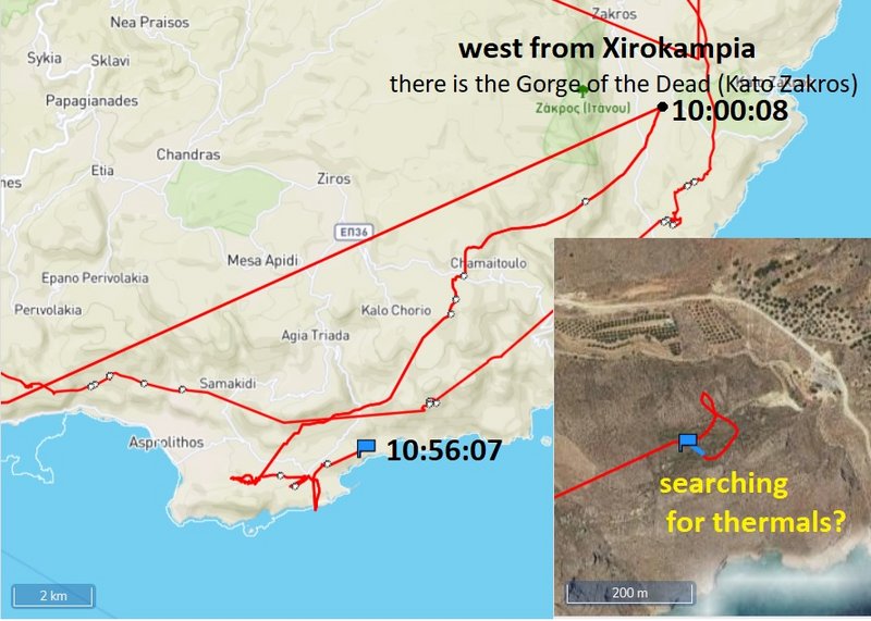
BLUE continued yesterday in his flight to the east. After night resting in the area the water reservoir of Bramiana (Techniti Limni Mpramianon) today morning flew again to the east.The last sent data are to the west from Xirokampia - there is the Gorge of the Dead (Kato Zakros)
BLUE is in the area from where Udu flew to Africa (Blue was currently a little further north)
more will follow little later - done
newest update:
BLUE is hesitating near the sea shore (last data at 10:56:07), the wind isn't favourable (NE)
-
marika.solo
- Site Admin
- Posts: 27553
- Joined: 29 Sep 2021, 09:38
Re: BS with transmitter from CZECHIA
BLUE - public map: https://www.makov.cz/clanky/telemetrie-makov-24.html
(previous post viewtopic.php?p=465#p465 + viewtopic.php?p=467#p467 and next)
previous data: 01.10 - localisation at 12.40h (UTC) NE from Gdochia a village on Crete 20 kilometers west of Ierapetra
new data: 02.10 - localisation at 10h (UTC) NW from steam electric station in Atherinolakkos village/Atherinolakkos power plant, located in Lasithi, the easternmost regional unit on the island of Crete
btw. On October 12, 2021 12:24 (UTC+3:30) offshore the island of Crete with a magnitude 6.4 Mw earthquake occurred with a maximum intensity of VIII (Severe) on the Modified Mercalli Intensity Scale
DISCOVERING CRETE on 01.11 + 02.11 to 10:56:07
Bramiana reservoire (night) BLUE visited this area on Oct 9 - photos, info viewtopic.php?p=135#p135 and on Oct 18 viewtopic.php?p=263#p263
Xirokampia: today's easternmost location at 10h and Blue turned back to the SE - STREET VIEW https://goo.gl/maps/gzsmkZ6VFfaKc38V6 image capture Sep 2011
(previous post viewtopic.php?p=465#p465 + viewtopic.php?p=467#p467 and next)
previous data: 01.10 - localisation at 12.40h (UTC) NE from Gdochia a village on Crete 20 kilometers west of Ierapetra
new data: 02.10 - localisation at 10h (UTC) NW from steam electric station in Atherinolakkos village/Atherinolakkos power plant, located in Lasithi, the easternmost regional unit on the island of Crete
btw. On October 12, 2021 12:24 (UTC+3:30) offshore the island of Crete with a magnitude 6.4 Mw earthquake occurred with a maximum intensity of VIII (Severe) on the Modified Mercalli Intensity Scale
DISCOVERING CRETE on 01.11 + 02.11 to 10:56:07
Gdochia 01.11 - 12.40 PHOTO https://thumbs.dreamstime.com/z/church- ... 132046.jpgmarika.solo wrote: ↑02 Nov 2021, 11:32... BLUE continued yesterday in his flight to the east. After night resting in the area the water reservoir of Bramiana (Techniti Limni Mpramianon) today morning flew again to the east.The last sent data are to the west from Xirokampia - there is the Gorge of the Dead (Kato Zakros)
BLUE is in the area from where Udu flew to Africa (Blue was currently a little further north) ...
Bramiana reservoire (night) BLUE visited this area on Oct 9 - photos, info viewtopic.php?p=135#p135 and on Oct 18 viewtopic.php?p=263#p263
Xirokampia: today's easternmost location at 10h and Blue turned back to the SE - STREET VIEW https://goo.gl/maps/gzsmkZ6VFfaKc38V6 image capture Sep 2011
-
marika.solo
- Site Admin
- Posts: 27553
- Joined: 29 Sep 2021, 09:38
Re: BS with transmitter from CZECHIA
BLUE - continuation
the area his newest localisations
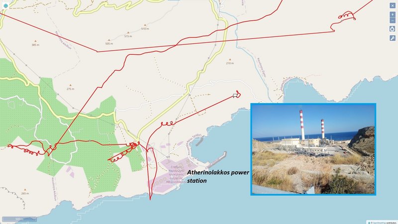
PHOTO https://goo.gl/maps/VnQUv2wDBfCCsXHS9 image capture Aug 2019
wider view on the Atherinolakkos power station area (we see there the area where is Blue that time)
Atherinolakkos from the air by Dimitris K.
(there are already to chimneys also here https://www.greece.com/photos/destinati ... os/4197560 + "In Atherinolakos in the southeast of Crete you find the power plant with its two red and white striped chimneys, that you can already see from a large distance. These chimneys are 125 meters high." source: https://www.angelfire.com/super2/greece ... lakos.html )
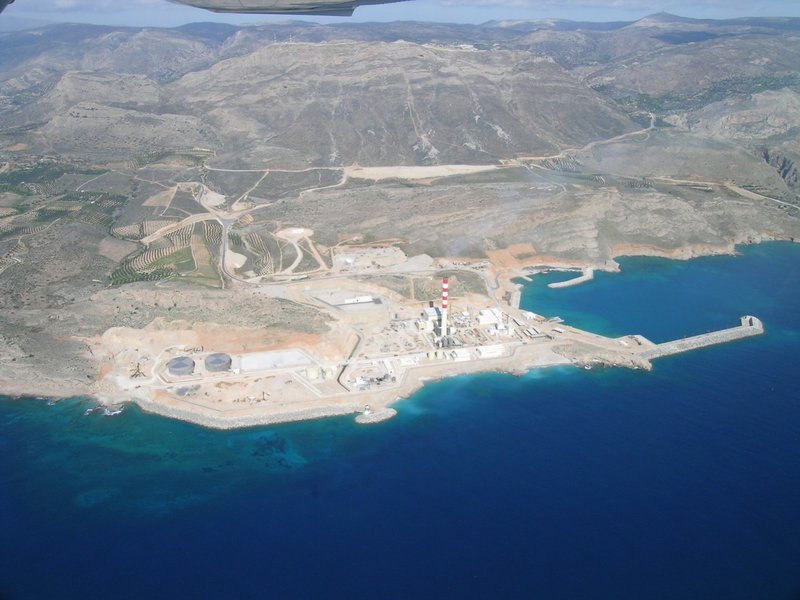
PHOTO - nice big + zoom https://images.greece.com/panoramio/07/ ... 71e8c8.jpg source: https://www.greece.com/photos/destinati ... ir/4199436
PHOTO view to the Libyan Sea https://goo.gl/maps/yhbTDYwLW6zL1RYZ7 image capture Aug 2020
marika.solo wrote: ↑02 Nov 2021, 11:32 ... newest update: BLUE is hesitating near the sea shore (last data at 10:56:07), the wind isn't favourable (NE)
the area his newest localisations
PHOTO https://goo.gl/maps/VnQUv2wDBfCCsXHS9 image capture Aug 2019
wider view on the Atherinolakkos power station area (we see there the area where is Blue that time)
Atherinolakkos from the air by Dimitris K.
(there are already to chimneys also here https://www.greece.com/photos/destinati ... os/4197560 + "In Atherinolakos in the southeast of Crete you find the power plant with its two red and white striped chimneys, that you can already see from a large distance. These chimneys are 125 meters high." source: https://www.angelfire.com/super2/greece ... lakos.html )
PHOTO - nice big + zoom
PHOTO view to the Libyan Sea https://goo.gl/maps/yhbTDYwLW6zL1RYZ7 image capture Aug 2020
-
marika.solo
- Site Admin
- Posts: 27553
- Joined: 29 Sep 2021, 09:38
Re: BS with transmitter from CZECHIA
November 03
Hello everyone
GREEN: searching for food still in the nearby new area (near the bike route not far from the island Donji Prut)
BLUE: SE Crete, Greece - near Atherinolakkos power plant, located in Lasithi, the easternmost regional unit on the island of Crete, in fly (next data session again in midday)
ORANGE: no new data
the non-public Anitra map and the simplified public Makov map (night resting places) ( https://www.makov.cz/clanky/telemetrie-makov-24.html)