previous data Oct 22 viewtopic.php?p=25341#p25341
next data Oct
October 23 data
Hello everyone

Birdmap update for
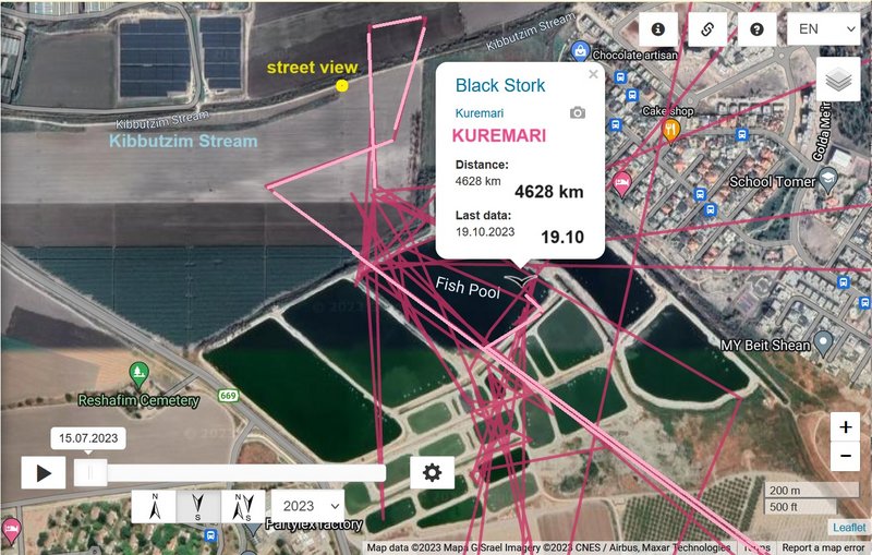
KUREMARI
https://birdmap.5dvision.ee/EN/2023/aut ... =0&speed=1
Previous data:
- 22.10.2023, Distance: 5190 km (+ 562 km in 3 days)
- EGYPT: Gebel El Zeit area - mountain in the Ra's Ghareb Municipality of the Red Sea Governorate
NEW data:
travelling
- 23.10.2023, Distance: 5520 km (+ 330 km)
- EGYPT: Edfu - a city in Edfu Municipality of Aswan Governorate (Upper Egypt)
(in the Eastern desert/Red Sea Mt. : to the east from Edfu and to the south from the Edfu-Mars Alama Road)
Kuremari continues its migration, flew further south. The newest localisation is in the area the Upper Egypt, east of the Historical landmark - Wadi Kanayis.
"The site of El Kanais lies around 55 km east of Edfu in the Wadi Mia, alongone of the major routes through the eastern desert between the Nile Valley and the Red Sea. Like many sites in the eastern and western deserts of Egypt, the rockface at El Kanais, which lies near a small pharaonic temple, proved attractive to graffiti writers over a long period of time."
(https://www.academia.edu/421443/Egyptia ... rn_Desert_)
Mairs, R. (2010) "Egyptian ‘Inscriptions’ and Greek ‘Graffiti’ at El Kanais (Egyptian Eastern Desert)," in Jennifer Baird and Claire Taylor (eds.), Ancient Graffiti in Context, 153-164. London: Routledge.


