October 16
Hello everyone
Birdmap update for KARL II https://birdmap.5dvision.ee/EN/2022/aut ... =0&speed=1
Previous data: (viewtopic.php?p=10519#p10519 and next)
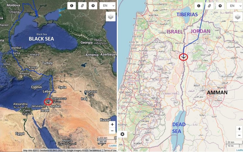
- 14.10.2022, Distance: 4561 km (+ 280 km)
- LEBANON: Younine - a town and a municipality in the Baalbek District of the Baalbek-Hermel Governorate in northeastern Lebanon
NEW data:
- 15.10.2022, Distance: 4775 km (+ 214 km)
- JORDAN: Salikhat w Hajijah - in Aghwar Shamaliyah District of Irbid Governorate
Karl II continued to the south - left the northern Lebanon and flew via Syria to Jordan valley (south from the lake Tiberias) near Kfar Ruppin (Israel). The newest localisation is on the fields (near one water tank) in border area - west from Salikhat w Hajijah.
more Adriána
btw.
Kfar Ruppin fishponds
"18. Black Stork - Count 16 - 15 Oct 2022 - Hugo Schweke (https://ebird.org/hotspot/L1286436)
KARL II, adult male from the streamed nest in Karula NP
-
- Site Admin
- Posts: 11553
- Joined: 29 Sep 2021, 09:38
Re: KARL II, adult male from the streamed nest in Karula NP
EDIT (Marika): it is the west side - Israel (we don't see there Karl's II area)
Photo Eugene Ivanov 3/2014 https://goo.gl/maps/QTgNGtJeEf2z1hgE7
-
- Site Admin
- Posts: 11553
- Joined: 29 Sep 2021, 09:38
Re: KARL II, adult male from the streamed nest in Karula NP
continuation
Karl's II localisation is most probably very similar (this photo is more to the south from his localisation)
https://lh5.googleusercontent.com/p/AF1QipM3Y6JDuvD0fmBL_pMrxkdkG270XsUt9xh03M5B=h1440 by sam nino
Karl's II localisation is most probably very similar (this photo is more to the south from his localisation)
https://lh5.googleusercontent.com/p/AF1QipM3Y6JDuvD0fmBL_pMrxkdkG270XsUt9xh03M5B=h1440 by sam nino
-
- Site Admin
- Posts: 11553
- Joined: 29 Sep 2021, 09:38
Re: KARL II, adult male from the streamed nest in Karula NP
MIGRATION - SITUATION as of 15.10
Last data: 15.10
Last data: 15.10
-
- Site Admin
- Posts: 11553
- Joined: 29 Sep 2021, 09:38
Re: KARL II, adult male from the streamed nest in Karula NP
October 17
Hello everyone
Birdmap update for KARL II https://birdmap.5dvision.ee/EN/2022/aut ... =0&speed=1
Previous data: (viewtopic.php?p=10542#p10542 and next)
- 15.10.2022, Distance: 4775 km (+ 214 km)
- JORDAN: Salikhat w Hajijah - in Aghwar Shamaliyah District of Irbid Governorate
NEW data:
- 16.10.2022, Distance: 5047 km (+ 272 km)
- ISRAEL: Neot Smadar - a kibbutz located in the Southern Negev Desert
(Abda Parking Lot - Hayon Camp Junction/Uvda Clifs)
Karl II continued to the south and his newest localisation is in the desert area not far from the Parking area (to the west is the Military Engineering School) and north from the Ovda Airport - a military air base in the Uvda region about 60km north of Eilat.
more Adriána
-
- Site Admin
- Posts: 11553
- Joined: 29 Sep 2021, 09:38
Re: KARL II, adult male from the streamed nest in Karula NP
continuation
links follows (little later) - done
1/ Hayon Camp Junction/Uvda Clifs https://goo.gl/maps/9xPx8AtEdw3G3Jdz6 image capture Feb 2021 by GA
Uvda is the name of a region in the southern Negev desert, directly north of Eilat. The name derives from the Hebrew word uvda (meaning fact). The region was captured during Operation Uvda in the 1948 Arab-Israeli War, when the Israel Defense Forces entered the area with the stated aim of establishing 'facts on the ground', hence the name. The Uvda Valley is known for the 7000-year-old Leopards Temple [he] archaeological site https://en.wikipedia.org/wiki/Uvda_(Israel) + https://www.jewishvirtuallibrary.org/operation-uvda
2/ Abda Parking Lot https://goo.gl/maps/NJq46NrPC3U7Ge8w5 image capture Dec 2020 by Oren Vilner
3/Kasuy Dunes https://goo.gl/maps/GA5yM4ijYe1NLNHYA image capture Jul 2021 by Alexey Goral
"the sand here is unusual: it turns out that about half of the grains that make up it are tiny, limestone fossils. What gives the dunes their special shape is the sand that comes from the Ovda Valley and just spills from the cliff steps. The wind renews the dune every day" (https://www.yaellernerturism.com/post/s ... -in-israel) + STREET VIEW https://goo.gl/maps/f5udh4chtzoVST4ZA Feb 2022 by Erez Gur
4/ Ovda airport general view from north 14-02-2019 by Oyoyoy https://commons.wikimedia.org/wiki/File ... -2019a.jpg
(https://en.wikipedia.org/wiki/Ovda_Airport)
-
- Site Admin
- Posts: 11553
- Joined: 29 Sep 2021, 09:38
Re: KARL II, adult male from the streamed nest in Karula NP
October 18
Hello everyone
Birdmap update for KARL II https://birdmap.5dvision.ee/EN/2022/aut ... =0&speed=1
Previous data: (viewtopic.php?p=10573#p10573 and next)
- 16.10.2022, Distance: 5047 km (+ 272 km)
- ISRAEL: Neot Smadar - a kibbutz located in the Southern Negev Desert
(Abda Parking Lot - Hayon Camp Junction/Uvda Clifs)
NEW data:
- 18.10.2022, Distance: 5707 km (+ 660 km in 2 days)
- EGYPT: Kom Ombo - town in Kom Ombo Merkez (district) of Aswan Governorate
Karl II continued to the south and flew paralell with the Gulf of Aqaba. The night spent on the Shadwan Island (Gulf of Suez) and today continued on his usually way to the Nile. The newest localisation is to the east from the town (rocky area south from the irrigated fields there).
more Adriána