BS with transmitter from nest in RS Makov (to 31.12.2021)

Post Reply
marika.solo
Site Admin
Posts: 11253
Joined: 29 Sep 2021, 09:38

Re: BS with transmitter from CZECHIA

Post by marika.solo »

GREEN public map: https://www.makov.cz/clanky/telemetrie-makov-24.html
(last post viewtopic.php?p=551#p551)

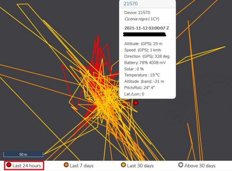
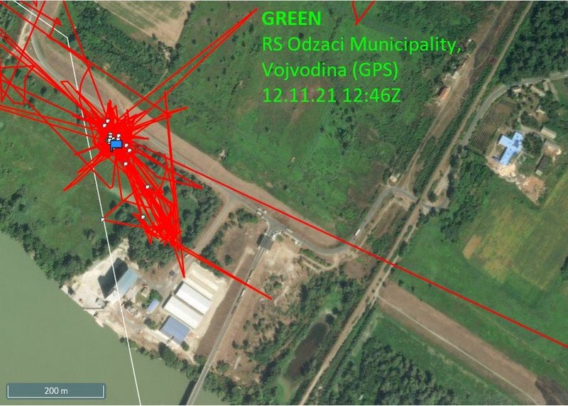
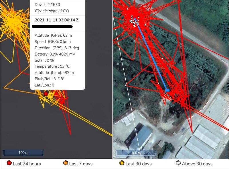
GREEN: stork spent all day on his newest favourite area (near the port) - approx 4 km from Bogojevo - village located in Odžaci municipality, West Bačka District, Serbia

on Nov 10 stork has localisations in this wet area near the route all day and night too (there are the localisations from previous days too - too much red lines); you can see this place on the street view (link down)

(red lines on the pic - "black"/to the left - are the yesterday moving/the last 24h)
Image

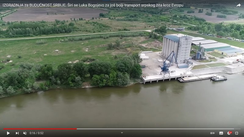
video the port area (dron view): https://youtu.be/fxu4oTwFTeY
photo - port: https://upload.wikimedia.org/wikipedia/ ... mbos02.JPG
street view Green's feeding/resting/night place: https://goo.gl/maps/LpfRUse8iRb1fNRK7

the port area these days https://goo.gl/maps/bLhJQdoXGDdvDL4u9
the nearby area these days https://www.facebook.com/bogojevovikend ... 3063133572

wider view on this area:
- map https://i.postimg.cc/tgtGBGTP/2021-11-06.jpg
- photo https://www.zvono.eu/images/139735.jpg or this https://goo.gl/maps/HhYrE5C4em8UKCFc7

live view on the Bogojevo border crossing point https://alltrafficcams.com/live/border- ... evo-erdut/ (2 cams - scroll down)
marika.solo
Site Admin
Posts: 11253
Joined: 29 Sep 2021, 09:38

Re: BS with transmitter from CZECHIA

Post by marika.solo »

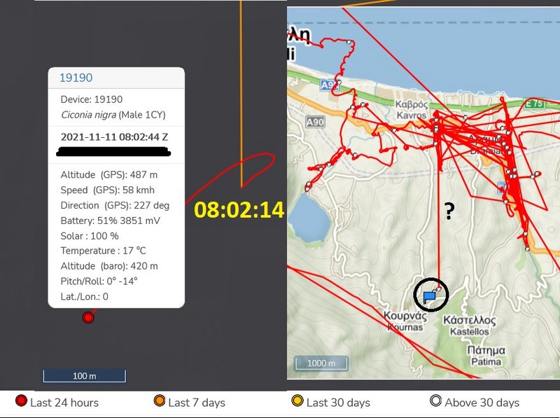
BLUE sent data :-) - more data are missing yet
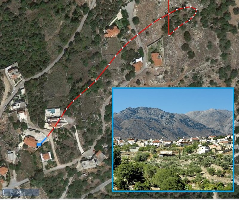
localisations are to the south from the previous last know place, south-east from the lake Kourna, in fly above the village Kournas.
more in the late afternoon or in the evening
marika.solo
Site Admin
Posts: 11253
Joined: 29 Sep 2021, 09:38

Re: BS with transmitter from CZECHIA

Post by marika.solo »

BLUE (text later - done)

BLUE - public map: https://www.makov.cz/clanky/telemetrie-makov-24.html
(previous post viewtopic.php?p=560#p560 and next)

previous data:
- 2021-11-09 at 10:00:10, west from Dramia (on "field") - a village in Georgioupoli (resort village and former municipality) in Chania regional unit in the Crete Region of Greece
new data:
- 2021-11-11 at 10:00:10, south from Dramia, south-east from the lake Kourna, in fly above the village Kournas
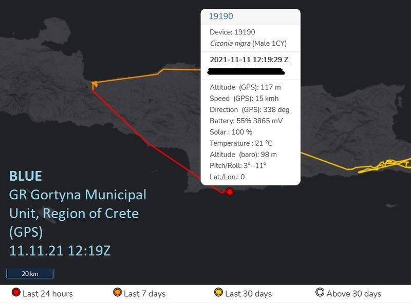
- 2021-11-11 at 12:19:49, on the southern part the island, above the sea south-east from Lentas - a coastal village on the south coast of Crete (near the Libyan Sea). It belongs to the community of Miamou within the municipality of Gortyna, Heraklion regional unit.

data sent at 10h (there are again big gaps)
Image

in fly above the village Kournas
Image
PHOTO: https://goo.gl/maps/t7aUCrbfxAMQ7B8k8 image taken Sep 2012

Image
PHOTO: https://goo.gl/maps/xCqCnrhyPTeJn3347 image taken Jul 2017

one other wider view on the area near Kournas https://goo.gl/maps/C8zazqwpA1QHLwvE8
marika.solo
Site Admin
Posts: 11253
Joined: 29 Sep 2021, 09:38

Re: BS with transmitter from CZECHIA

Post by marika.solo »

BLUE more later - done

2021-11-11 at 12:19:49 - on the southern part the island, above the sea south-east from Lentas - a coastal village on the south coast of Crete (near the Libyan Sea). It belongs to the community of Miamou within the municipality of Gortyna, Heraklion regional unit

data sent at 12:19:49 h (there are again big gaps)
Image

BLUE isn't very far from the shore (finger crossed very, very much)
Image

edit:
here we see the area in which the stork has locations above the sea
Image
STREET VIEW https://goo.gl/maps/F1hXoXsy2Ge9rsUn9 image capture Sep 2020

I apologize - Blue will be documented (I will complete and describe) only on Saturday afternoon or early evening
I will try to write the latest information continuously in the morning
- done
marika.solo
Site Admin
Posts: 11253
Joined: 29 Sep 2021, 09:38

Re: BS with transmitter from CZECHIA

Post by marika.solo »

BLUE is on the east edge the island (2021-11-12 at 12:11:21)
there are again big gaps - click: https://i.postimg.cc/pVJtGvXj/2021-11-1 ... midday.jpg
Flights2
Posts: 28
Joined: 29 Sep 2021, 15:46

Re: BS with transmitter from CZECHIA

Post by Flights2 »

marika.solo wrote: 12 Nov 2021, 14:49
uf, OK. good message :-) thanks, Mariko, for evryday news.
tyjo jsem se překonal
marika.solo
Site Admin
Posts: 11253
Joined: 29 Sep 2021, 09:38

Re: BS with transmitter from CZECHIA

Post by marika.solo »

November 12
Hello everyone :-)

GREEN: newest data 2021-11-11 03.00, stork spent all day on his newest favourite area, near the port; approx 4 km from Bogojevo - village located in Odžaci municipality, West Bačka District, Serbia
BLUE: last data 2021-11-11 at 12:19:29, in fly to the south (maybe) above the Kournas village (traditional village about 4 km from Lake Kournas) in the Apokoronas municipality of Chania regional unit on the island of Crete, Greece (situation/Anitra map - click https://i.postimg.cc/rscVzCMZ/2021-11-1 ... orning.jpg)
ORANGE: no new data - last data 19.09 (viewtopic.php?p=58#p58)

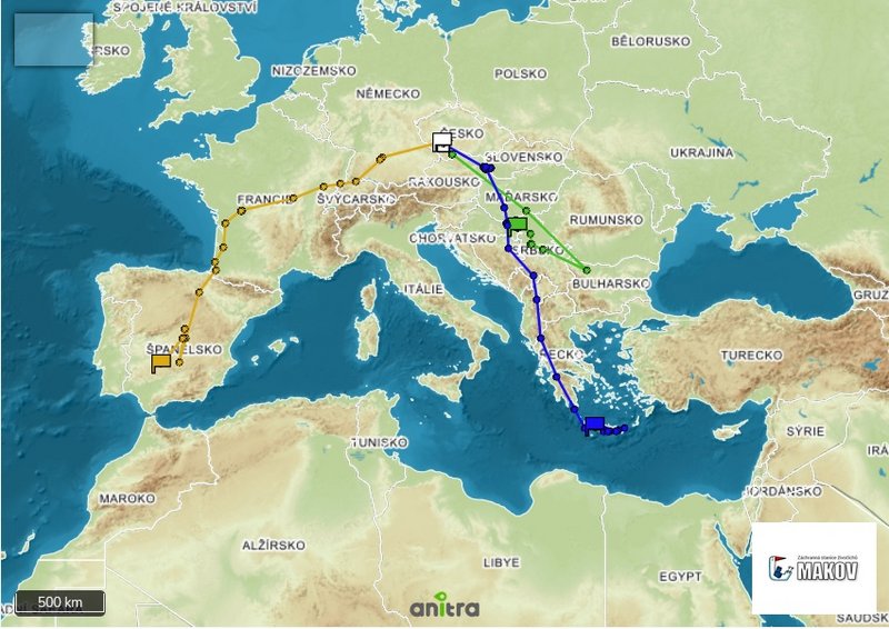
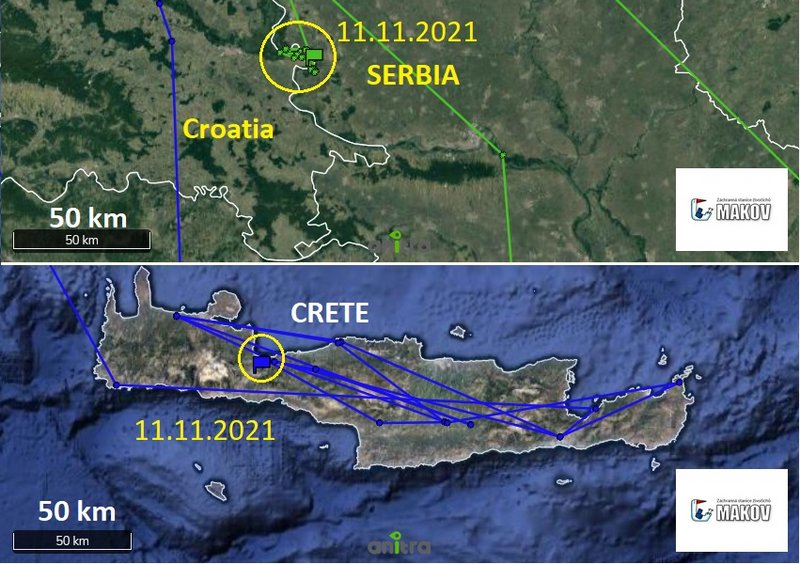
GREEN arrived to this area on Sep 11 (Gornje Podunavlje Special Nature Reserve is a large protected area of wetland in the northwest of Serbia, on the Danube's left bank)
BLUE arrived in Crete on Oct 7

Image

difference in the action radius of storks/area of the moving (simplified Makov map)
Image
marika.solo
Site Admin
Posts: 11253
Joined: 29 Sep 2021, 09:38

Re: BS with transmitter from CZECHIA

Post by marika.solo »

GREEN public map: https://www.makov.cz/clanky/telemetrie-makov-24.html
(viewtopic.php?p=559#p559)

GREEN: stork spent all day on his newest favourite area (near the port) - approx 4 km from Bogojevo - village located in Odžaci municipality, West Bačka District, Serbia

on Nov 11 stork has localisations in this wet area near the route; you can see this place on the street view (link down)

(red lines in the picture are yesterday's movements / last 24 hours)
Image

today last data session
Image

aerial view on this area :-)
Image
short VIDEO - great views https://youtu.be/HG3DOeUTpfM uploaded 14.05.2021

video the port area (dron view): https://youtu.be/fxu4oTwFTeY
photo - port: https://upload.wikimedia.org/wikipedia/ ... mbos02.JPG
street view Green's feeding/resting/night place: https://goo.gl/maps/LpfRUse8iRb1fNRK7

the port area these days https://goo.gl/maps/bLhJQdoXGDdvDL4u9
the nearby area these days https://www.facebook.com/bogojevovikend ... 3063133572

wider view on this area:
- map https://i.postimg.cc/tgtGBGTP/2021-11-06.jpg
- photo https://www.zvono.eu/images/139735.jpg or this https://goo.gl/maps/HhYrE5C4em8UKCFc7

live view on the Bogojevo border crossing point https://alltrafficcams.com/live/border- ... evo-erdut/ (2 cams - scroll down)
marika.solo
Site Admin
Posts: 11253
Joined: 29 Sep 2021, 09:38

Re: BS with transmitter from CZECHIA

Post by marika.solo »

BLUE - public map: https://www.makov.cz/clanky/telemetrie-makov-24.html
(previous post viewtopic.php?p=561#p561)

previous data:
- 2021-11-11 at 10:00:10, south from Dramia, south-east from the lake Kourna, in fly above the village Kournas
- 2021-11-11 at 12:19:49, on the southern part the island, above the sea south-east from Lentas - a coastal village on the south coast of Crete (near the Libyan Sea). It belongs to the community of Miamou within the municipality of Gortyna, Heraklion regional unit
new data:
- 2021-11-12 at 10h
- 2021-11-12 at 12h
- 2021-11-12 at 14h

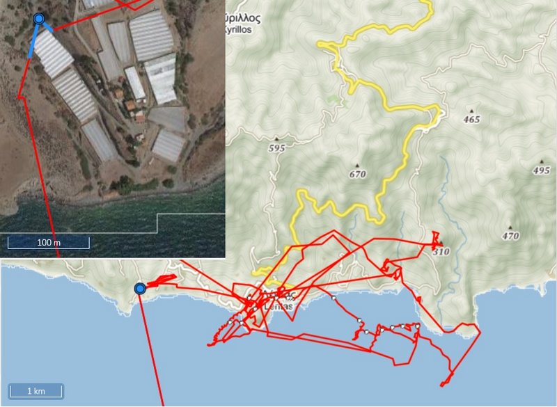
night places
Image

the night area 11./12.11 = blue dot (stork spent the night in a tree by the greenhouses)
Image

3D view on the area (click) https://i.postimg.cc/XYPmzFNz/2021-11-1 ... D-view.jpg

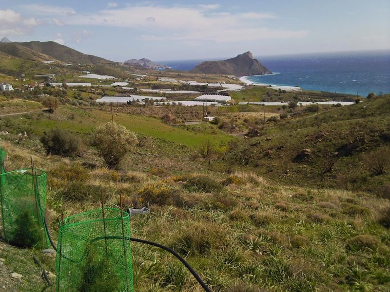
view on the area where our Blue explored the area on 11.11 from exactly 12:00:07 to 06:10:08 on 12.11.2021
Image
big PHOTO https://lh5.googleusercontent.com/p/AF1 ... LVOrp=h720
marika.solo
Site Admin
Posts: 11253
Joined: 29 Sep 2021, 09:38

Re: BS with transmitter from CZECHIA

Post by marika.solo »

BLUE today

situation at 12h

BLUE started to his flight in early morning at 06:10:08; there are again big gaps (no data/no localisations)

we don't know if stork flew over sea:
- previous data at 08:10:07 (above the sea south from the night place)
- the next data at 10:01:13 already already relatively far east on the mainland not far from Mirtos (to the NE, in fly)
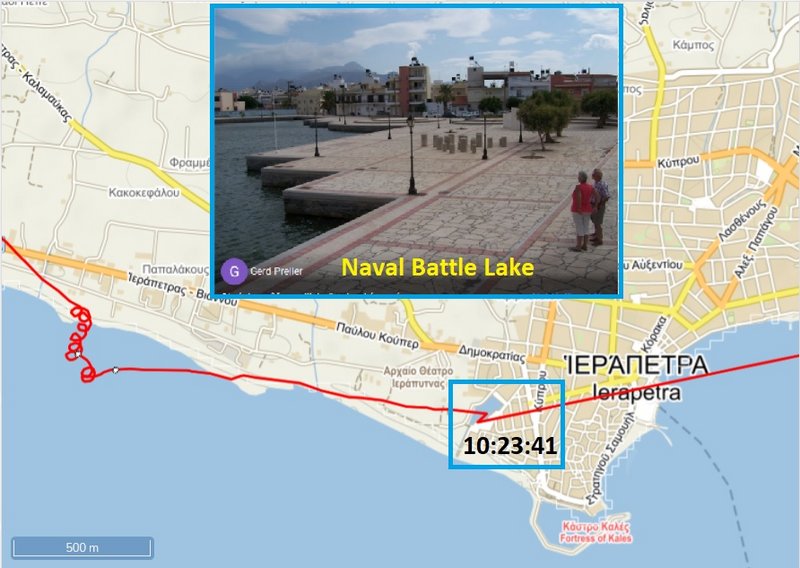
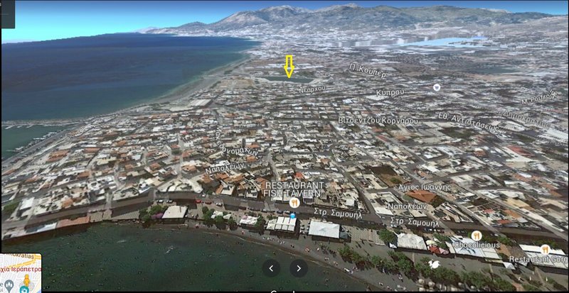
- stork continued direction to Iaerepetra and there he has localisations again above the open sea, this time very near the seashore and most probably flew above the town (there is the next gaps) = center of line in image/number of lines
- new data are already on the east edge the island near Kato Zakros and we received again data at 14h, Blue continued to the north-east again

Image

The site of the Naumachia of Ierapetra was transformed to a lake that communicated with the sea through a narrow canal, from where the ships entered. infos and photos eg here https://www.cretanbeaches.com/en/histor ... -ierapetra

Image
photo https://lh5.googleusercontent.com/p/AF1 ... -h306-k-no

STREET VIEW https://i.postimg.cc/0yDZY22L/2021-11-1 ... t-view.jpg - near the pond - canal https://goo.gl/maps/NazQCrHbCf1SxveDA and the other site https://goo.gl/maps/UD4YvGPKh6iBR2GR6

Iaepetra (3D google map - no the best)
Image
PIC https://goo.gl/maps/3LQmtNAAG62M3t6t7 Oct 2016
Post Reply

Return to “Czechia”