BS with transmitter from nest in RS Makov (to 31.12.2021)

Post Reply
marika.solo
Site Admin
Posts: 18015
Joined: 29 Sep 2021, 09:38

Re: BS with transmitter from CZECHIA

Post by marika.solo »

BLUE - public map: https://www.makov.cz/clanky/telemetrie-makov-24.html
(previous post viewtopic.php?p=487#p487)

previous data:
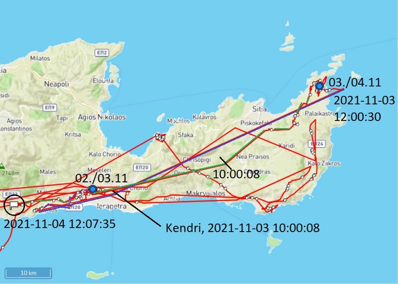
03.10 - localisation at 10h (UTC) north from Kentri (in fly) - village in the municipality of Ierapetra - stork continued to the NE end of island (last data 12.48)
new data:
04.10 - localisation at 10h (UTC) north from Lithines (in fly) - large village located in the southeast of Crete on the way from Sitia in the north to Makrigialos in the south; stork continued to the SW (last data: 12.07)

BLUE on Nov 03

PART 1 - yesterday data viewtopic.php?p=489#p489
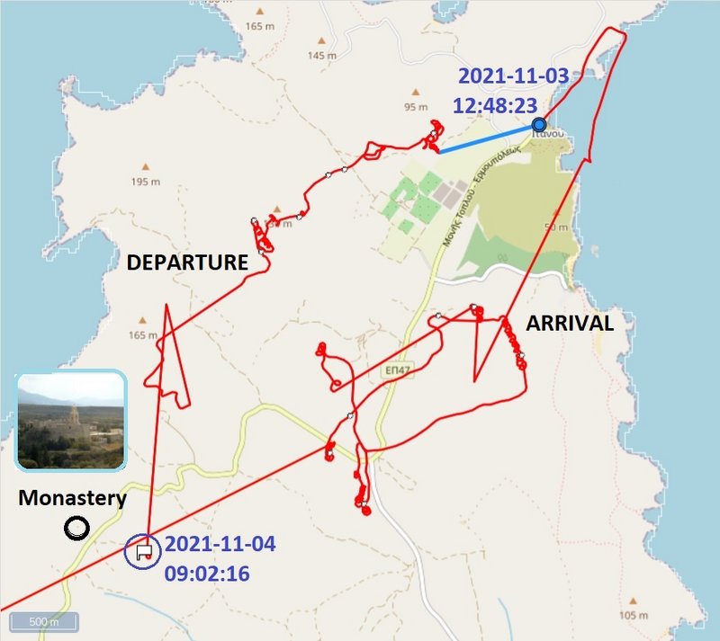
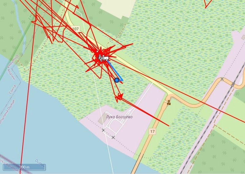
BLUE flew after night resting in the area of Bramiana in the morning to the SW. Approx. at 9.22 (not far from the sea) turned to the east and continued to the almost northeastern tip of the island of Crete (missed data from 10h, Kentri to 12.26 already on NE edge). The last data sent Blue yesterday at 12:48:23.

the whole yesterday known fly-path (click) https://i.postimg.cc/XqxhD27L/2021-11-0 ... -11-am.jpg

wider view on the area there
Image
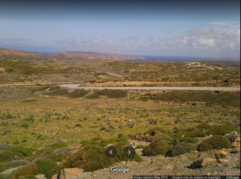
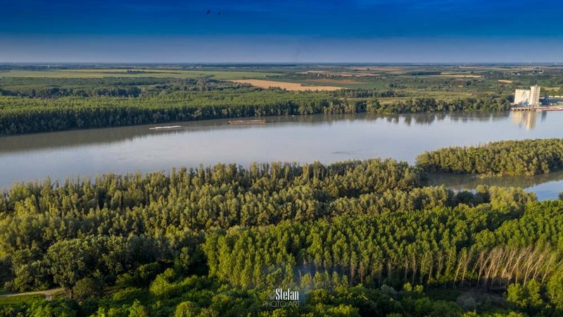
PHOTO https://goo.gl/maps/EyueqWdkAN9ZVSJFA image capture May 2013

PART 2 - today data
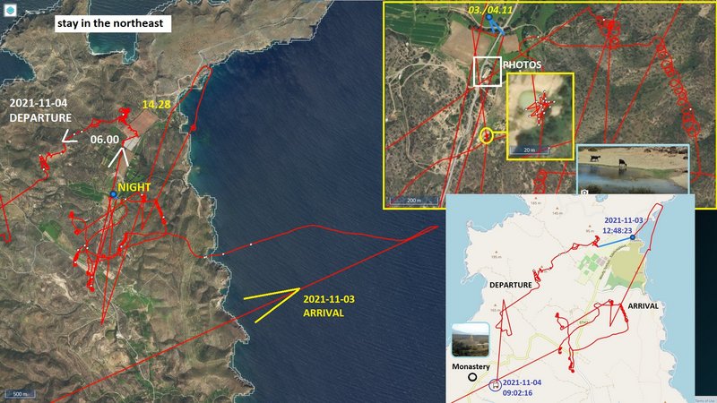
The data gradually came - BLUE spent the night in the area on NE

situation in the morning - the first update
Image

situation afterthe next update - there we see Blue flew again over the sea but quickly turned back
most probably he was looking for thermals, but finally landed on land and was looking for food

Image
marika.solo
Site Admin
Posts: 18015
Joined: 29 Sep 2021, 09:38

Re: BS with transmitter from CZECHIA

Post by marika.solo »

BLUE continuation

Image

maybe this is where the stork was looking for food

Image
PHOTO https://goo.gl/maps/1xps5Z3NYuaAeQDu8 image capture Sep 2011

the nearby area to the south from his night resting palce

Image
PHOTO https://goo.gl/maps/f2HL6s5L77zMMLuz6 image capture Sep 2020
marika.solo
Site Admin
Posts: 18015
Joined: 29 Sep 2021, 09:38

Re: BS with transmitter from CZECHIA

Post by marika.solo »

BLUE on Nov 04

the whole path on Nov 3 (blue) and today path (green)
Image

BLUE at 6h already started to his next fly - continued back to the south - south-west on the island (the red line)
Image

at 9.02 his localisations is nearby the Toplou Monastery (near Sitia) https://en.wikipedia.org/wiki/Toplou_Monastery

infos and photos e.g. https://www.cretanbeaches.com/en/religi ... -sitia-vai or https://www.angelfire.com/super2/greece/toplou.html

Image
By Wouter Hagens - Own work, CC BY-SA 3.0, https://commons.wikimedia.org/w/index.php?curid=4170338
marika.solo
Site Admin
Posts: 18015
Joined: 29 Sep 2021, 09:38

Re: BS with transmitter from CZECHIA

Post by marika.solo »

BLUE continuation

the localisation at 10h (in fly) is north from Lithines
infos , photos eg https://www.angelfire.com/super2/greece/lithines.html or https://www.cretanbeaches.com/en/histor ... ines-tower

Image
https://www.angelfire.com/super2/greece ... 13/537.JPG

stork continued to SW and sent data at 12:07:35 from there

Image
STREET VIEW https://goo.gl/maps/snwDpMiGD646WPNk7 image capture Sep 2011

Image
marika.solo
Site Admin
Posts: 18015
Joined: 29 Sep 2021, 09:38

Re: BS with transmitter from CZECHIA

Post by marika.solo »

November 05
Hello everyone :-)

GREEN: stork spent all day on his newest favourite area, near the port; approx 4 km from Bogojevo - village located in Odžaci municipality, West Bačka District, Serbia
BLUE: newest localisation is in fly, SW from Sikologos (north from Sidonia) - a village and a community in the southeastern part of the Heraklion regional unit, in Crete, Greece (next data session maybe in midday)
ORANGE: no new data

the non-public Anitra map and the simplified public Makov map (night resting places) ( https://www.makov.cz/clanky/telemetrie-makov-24.html)
maps follow - done

Image

Image

BLUE newest situation: https://i.postimg.cc/VN51cDfZ/2021-11-0 ... at-12h.jpg
marika.solo
Site Admin
Posts: 18015
Joined: 29 Sep 2021, 09:38

Re: BS with transmitter from CZECHIA

Post by marika.solo »

GREEN public map: https://www.makov.cz/clanky/telemetrie-makov-24.html
(last post viewtopic.php?p=494#p494)

GREEN stork spent all day on his newest favourite area (near the port) - approx 4 km from Bogojevo - village located in Odžaci municipality, West Bačka District, Serbia

today, the data table can be closed, so we can clearly see the movement of the stork over the last 24 hours (red lines) - GREEN moved on little place

Image

Лука Дунав - Богојево/Luka Dunav - Bogojevo = Danube Port - Bogojevo
Image

wide view from Erdut to the port (in the right upper corner)
Image
PHOTO https://www.zvono.eu/images/139735.jpg (source https://www.zvono.eu/zelene-staze-dunava-i-drave-444)
marika.solo
Site Admin
Posts: 18015
Joined: 29 Sep 2021, 09:38

Re: BS with transmitter from CZECHIA

Post by marika.solo »

BLUE - description later
click for big pic

the first data arrived :-)
Image

EDIT next data arrived - loc. at 10h
Image

EDIT and again new data - loc. at 12.37 (most probably the last data today)
Image
marika.solo
Site Admin
Posts: 18015
Joined: 29 Sep 2021, 09:38

Re: BS with transmitter from CZECHIA

Post by marika.solo »

most probably not our Blue, but another young black stork is captured in a photo from Vai at noon on November 3

At Vai, at noon ... sent by friend from Crete
photo shared by Mr. Bohumil Mášek https://www.facebook.com/groups/capiboh ... 1007095519

Image
PHOTO https://scontent.fksc1-1.fna.fbcdn.net/ ... e=61ABFEB2

Image
marika.solo
Site Admin
Posts: 18015
Joined: 29 Sep 2021, 09:38

Re: BS with transmitter from CZECHIA

Post by marika.solo »

BLUE - public map: https://www.makov.cz/clanky/telemetrie-makov-24.html
(previous post viewtopic.php?p=497#p497 and next + today data viewtopic.php?p=504#p504)

after consulting with friends (Madli, Lukáš) I decided to the description of one day - from midnight to midnight (although I have newer data available)

previous data:
- midnight 03.11/04.11: Itanos, Lasithi regional unit, eastern Crete, Greece
new data:
- midnight 04.11/05.11: not far from Tefeli - a little village in Asteroussioi in Heraklion regional unit in the Crete Region of Greece

discovering Crete on Nov 04

THE FIRS PART OF THE DAY (to 12.07) viewtopic.php?p=499#p499

Image

THE SECOND PART OF THE DAY (from 12.07):
- Blue continued to the west (NW), there is gap from 12.07 to 13.02
- the next localisations are near one stream or creek not far from Tefeli - it seems stork searched there for food (he visited this place already on Oct 18) and then flew to the nearby pond/reservoir

night place 04./05.11
- Blue arrived there at 14.45; stork after night resting flew to same nearby places already at 3h (searching for food?) and left this area at 8.10

Image

Tefeli area
Image
PHOTO https://images.greece.com/panoramio/07/ ... ca3f0b.jpg (source and more photos https://www.greece.com/photos/destinati ... )/53718156)
marika.solo
Site Admin
Posts: 18015
Joined: 29 Sep 2021, 09:38

Re: BS with transmitter from CZECHIA

Post by marika.solo »

November 06
Hello everyone :-)

GREEN: stork spent all day on his newest favourite area, near the port; approx 4 km from Bogojevo - village located in Odžaci municipality, West Bačka District, Serbia
BLUE: midnight 04.11/05.11: not far from Tefeli - a little village in Asteroussioi in Heraklion regional unit in the Crete Region of Greece
ORANGE: no new data

the non-public Anitra map and the simplified public Makov map (night resting places) ( https://www.makov.cz/clanky/telemetrie-makov-24.html)
maps follows - done

Image

for comparison (same map scale):
BLUE - almost the entire island of Crete (approx. 260 km x 60km/the widest, resp. 12km/the narrowest place), GREEN - area less than 20x20km

Image

BLUE last update on Nov 05 (still in fly) https://i.postimg.cc/Nj0tfjg0/2021-11-0 ... ng-sit.jpg
Post Reply

Return to “Czechia”