
OCTOBER 10
Birdmap update 09.10.21
KARL II http://birdmap.5dvision.ee/EN/2021/autu ... =0&speed=1
(previous post )
Previous data: 08.10.21. Distance 2360 km(+23km) Near Oleksandrivka and Pereskops'ka gulf, Ukraine.
No New Data!
PIKNE http://birdmap.5dvision.ee/EN/2021/autu ... =0&speed=1
(previous post )
Previous data: 08.10.21. Distance 2915 km (+9km). Pikne is back on the fields near Gura Ialomiței, Romania.
No New Data!
BS from ESTONIA with transmitter (to 31.12.2021)
Re: BS with transmitter from ESTONIA
UDU Info:http://birdmap.5dvision.ee/EN/2021/autu ... =0&speed=1
(previous post )
Birdmap update 09.10.21
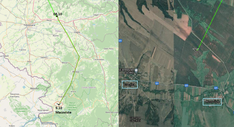
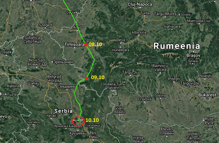
Previous data: 08.10.21. Distance 3029 km(+185km). Udu is near Cralovăț, a village in Timiș County, Romania.
New data: 09.10.21. Distance 3140km (+111km) Near Macoviște, a village in the commune of Ciuchici in Caraș-Severin County, Banat, Romania.
3D animation by Lukaš: https://ayvri.com/scene/ykxwgxee59/ckuk ... 6kqbcsxan5
Macoviste village
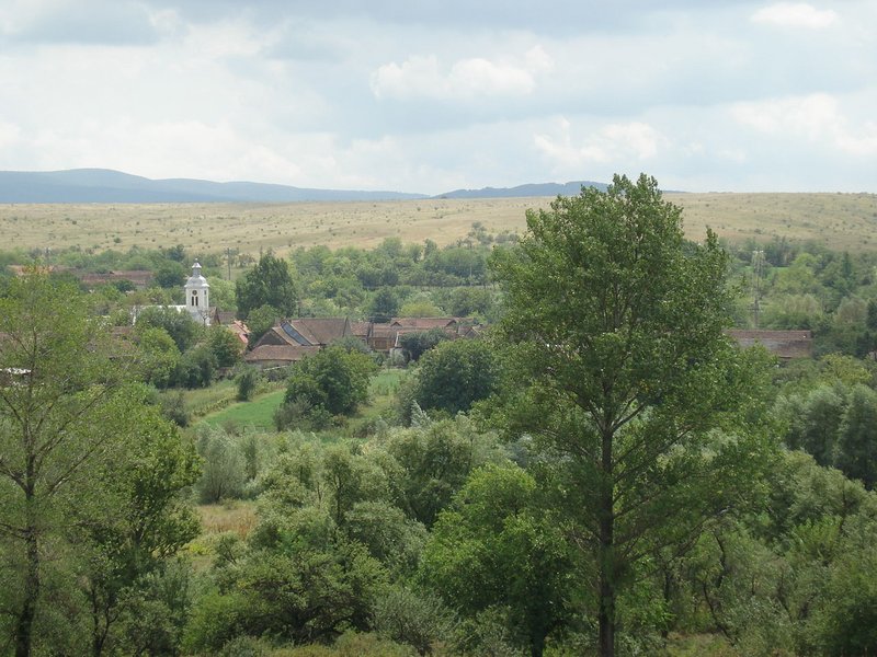
https://ro.wikipedia.org/wiki/Macovi%C8 ... oviste.JPG
(previous post )
Birdmap update 09.10.21
Previous data: 08.10.21. Distance 3029 km(+185km). Udu is near Cralovăț, a village in Timiș County, Romania.
New data: 09.10.21. Distance 3140km (+111km) Near Macoviște, a village in the commune of Ciuchici in Caraș-Severin County, Banat, Romania.
3D animation by Lukaš: https://ayvri.com/scene/ykxwgxee59/ckuk ... 6kqbcsxan5
Macoviste village
https://ro.wikipedia.org/wiki/Macovi%C8 ... oviste.JPG
Re: BS with transmitter from ESTONIA
UDU continuation
There seems to be a lot of electric lines in that area. I personally hope that Udu will not stop in this area for a long time, just a fly-over.
View to the fields and landscape where Udu flew over.
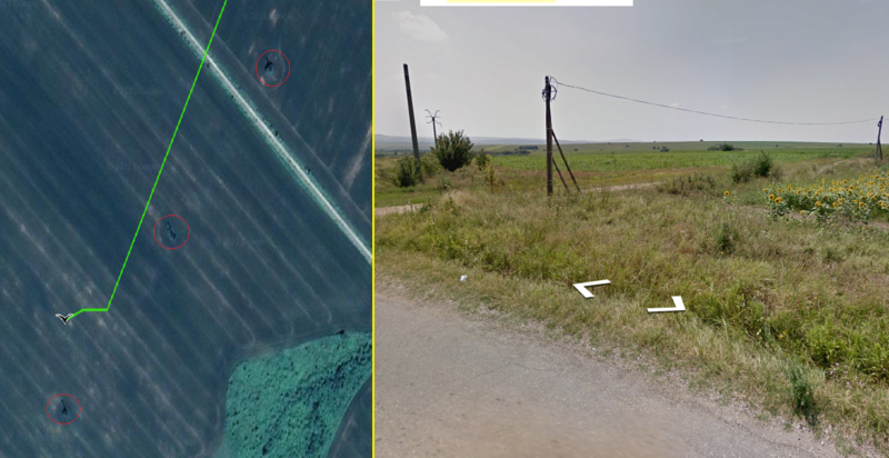
https://www.instantstreetview.com/@44.9 ... Gk1nvzjhrg
From the more detailed view from the Tracker map we can see that there are also wind turbines in the area
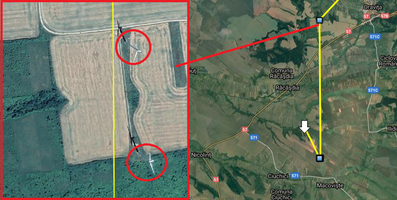
Tracker map is provided by Ornitela. https://www.ornitela.com
https://www.google.com/maps/d/viewer?mi ... 95977&z=15
A view of the area from Oravita
https://lh5.googleusercontent.com/p/AF1 ... qzLn=h1440
There seems to be a lot of electric lines in that area. I personally hope that Udu will not stop in this area for a long time, just a fly-over.
View to the fields and landscape where Udu flew over.
https://www.instantstreetview.com/@44.9 ... Gk1nvzjhrg
From the more detailed view from the Tracker map we can see that there are also wind turbines in the area
Tracker map is provided by Ornitela. https://www.ornitela.com
https://www.google.com/maps/d/viewer?mi ... 95977&z=15
A view of the area from Oravita
https://lh5.googleusercontent.com/p/AF1 ... qzLn=h1440
Re: BS with transmitter from ESTONIA
OCTOBER 11
KARL II Info:http://birdmap.5dvision.ee/EN/2021/autu ... =0&speed=1
(previous post )
Tracker map update for 10.10.21 https://www.google.com/maps/d/edit?mid= ... sp=sharing
Tracker map is provided by https://www.ornitela.com
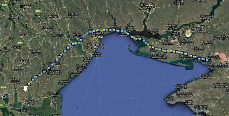
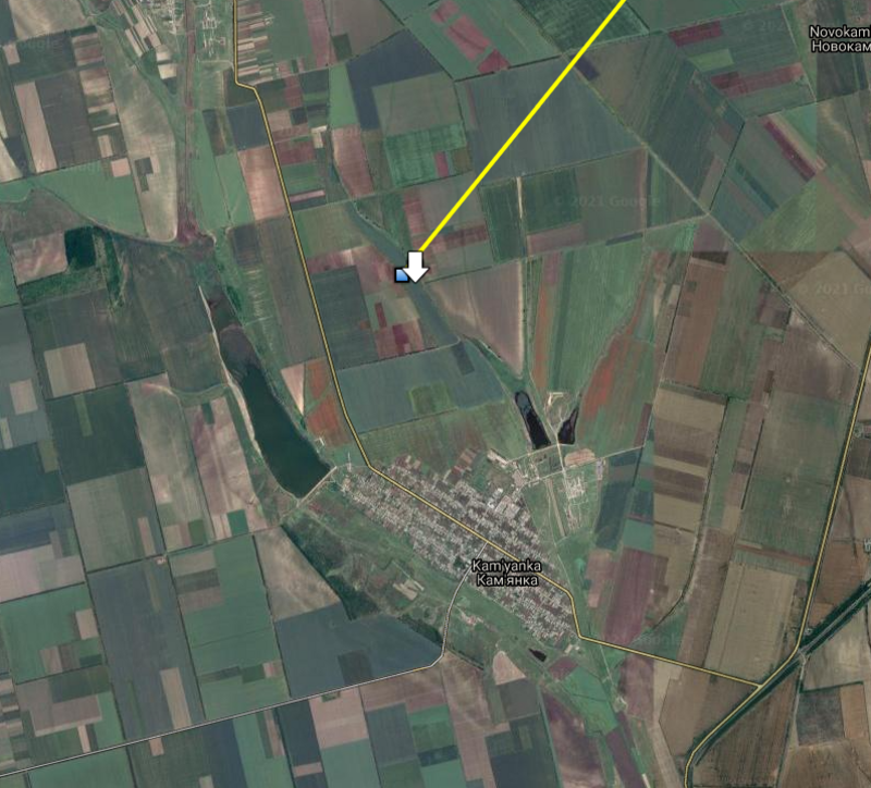
Karl stopped near Kam'yanka, Izmail Raion, Odessa Oblast, Ukraine
Karl is on the move! Total distance flown 421 km!
Lukaš:" The wind helped him a lot today. Karl flew all the way with the wind at his back. the wind had a force of 25 km / h helped him a lot on the way forward. Karl used an air lift several times along the way so that he wouldn't have to bother so much. The sun was probably shining and there were several favorable conditions above the mainland for the formation of thermal rising currents in the atmosphere."
3D animation here: https://ayvri.com/scene/ykxwgxee59/ckul ... 6k06lzwt6g
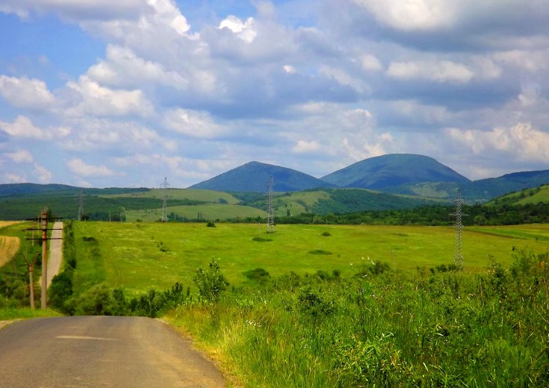
View to the fields from Kam'yanka
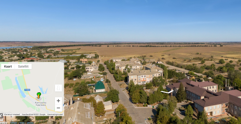
https://www.instantstreetview.com/@45.5 ... RJWHJVbjVl
KARL II Info:http://birdmap.5dvision.ee/EN/2021/autu ... =0&speed=1
(previous post )
Tracker map update for 10.10.21 https://www.google.com/maps/d/edit?mid= ... sp=sharing
Tracker map is provided by https://www.ornitela.com
Karl stopped near Kam'yanka, Izmail Raion, Odessa Oblast, Ukraine
Karl is on the move! Total distance flown 421 km!
Lukaš:" The wind helped him a lot today. Karl flew all the way with the wind at his back. the wind had a force of 25 km / h helped him a lot on the way forward. Karl used an air lift several times along the way so that he wouldn't have to bother so much. The sun was probably shining and there were several favorable conditions above the mainland for the formation of thermal rising currents in the atmosphere."
3D animation here: https://ayvri.com/scene/ykxwgxee59/ckul ... 6k06lzwt6g
View to the fields from Kam'yanka
https://www.instantstreetview.com/@45.5 ... RJWHJVbjVl
Re: BS with transmitter from ESTONIA
PIKNE Info: http://birdmap.5dvision.ee/EN/2021/autu ... =0&speed=1
(previous post )
Tracker map update 9.-10.10.21
Tracker map for 09.10.21 https://www.google.com/maps/d/viewer?mi ... 00018&z=14
Tracker map for 10.10.21 https://www.google.com/maps/d/viewer?mi ... 00014&z=14
Tracker map is provided by https://www.ornitela.com
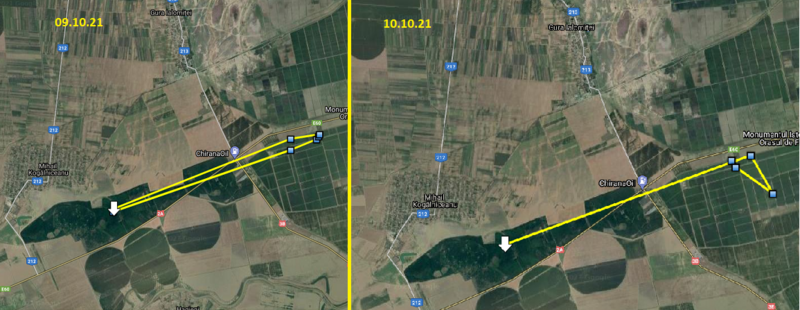
Pikne is still at the same place, going back and forth between the fields and Mihail Kogălniceanu.
(previous post )
Tracker map update 9.-10.10.21
Tracker map for 09.10.21 https://www.google.com/maps/d/viewer?mi ... 00018&z=14
Tracker map for 10.10.21 https://www.google.com/maps/d/viewer?mi ... 00014&z=14
Tracker map is provided by https://www.ornitela.com
Pikne is still at the same place, going back and forth between the fields and Mihail Kogălniceanu.
Re: BS with transmitter from ESTONIA
UDU Info:http://birdmap.5dvision.ee/EN/2021/autu ... =0&speed=1
(previous post )
Birdmap update for 10.10 21
Previous data: 09.10.21. Distance 3140km (+111km) Near Macoviște, a village in the commune of Ciuchici in Caraș-Severin County, Banat, Romania.
New data: 10.10.21. Distance 3291 km(+151km) Udu is by the Velika Morava river near Donje Vidovo in Paracin municipality, Serbia.
Information from Lukaš: "Its map tracker has very little information. On his way, a very strong wind blew from his left side. Very strong east wind with a force of approximately 50 km / h. it had to give him a lot of work to maintain the southern direction of the flight. he could not use the thermals. he fluttered his wings all the way."
You can see it in 3D here: https://ayvri.com/scene/ykxwgxee59/ckul ... 6ke4z3ao7w
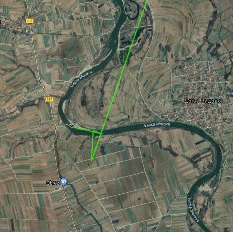
Velika Morava river in the area of Donje Vidovo.
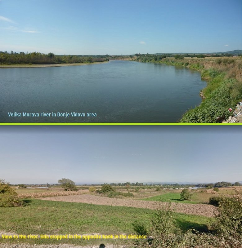
Photo1: https://mapio.net/images-p/77227559.jpg
Photo2(Street view):https://www.google.com/maps/@43.7966345 ... 312!8i6656
(previous post )
Birdmap update for 10.10 21
Previous data: 09.10.21. Distance 3140km (+111km) Near Macoviște, a village in the commune of Ciuchici in Caraș-Severin County, Banat, Romania.
New data: 10.10.21. Distance 3291 km(+151km) Udu is by the Velika Morava river near Donje Vidovo in Paracin municipality, Serbia.
Information from Lukaš: "Its map tracker has very little information. On his way, a very strong wind blew from his left side. Very strong east wind with a force of approximately 50 km / h. it had to give him a lot of work to maintain the southern direction of the flight. he could not use the thermals. he fluttered his wings all the way."
You can see it in 3D here: https://ayvri.com/scene/ykxwgxee59/ckul ... 6ke4z3ao7w
Velika Morava river in the area of Donje Vidovo.
Photo1: https://mapio.net/images-p/77227559.jpg
Photo2(Street view):https://www.google.com/maps/@43.7966345 ... 312!8i6656
-
marika.solo
- Site Admin
- Posts: 26955
- Joined: 29 Sep 2021, 09:38
Re: BS with transmitter from ESTONIA
Hi Madli,
thank you for all updates. Very good job!
It is strange that Urmas updated the birdmap data only for Udu last night.
thank you for all updates. Very good job!
It is strange that Urmas updated the birdmap data only for Udu last night.
Re: BS with transmitter from ESTONIA
Hi, Marika. Katrin also got the update. But it is very strange indeed.marika.solo wrote: ↑11 Oct 2021, 09:19 Hi Madli,
thank you for all updates. Very good job!
It is strange that Urmas updated the birdmap data only for Udu last night.
-
marika.solo
- Site Admin
- Posts: 26955
- Joined: 29 Sep 2021, 09:38
Re: BS with transmitter from ESTONIA
But also on the Birdmap. I thought that out of all the storks on the map, only they two got the update...Maybe Urmas is more interested in them?