MARE, adult female https://goris.lv/mare-2017/
MARE (0C9X) - adult female hatched in Latvia 2016
Ring ID: LVR ET-5389
Tag: 2699; Start of tag deployment: 2016-08-03 00:00:00.000; Deployment Id: 2699@Penkule new 2; Time of First Location: 2016-08-17 08:40:31.998
Penkule is a village in Penkule Parish and Dobele Municipality in the historical region of Zemgale, and the Zemgale Planning Region in Latvia
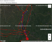
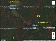
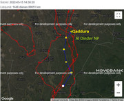
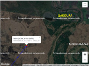
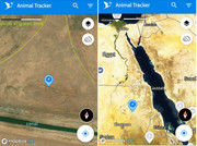
MARE is on her way to the north - fly safe!
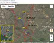
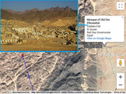
- last autumn update (wintering place in Ethiopia) viewtopic.php?p=1198#p1198
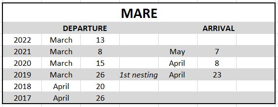
2021: Mare had a very long break in Greece, late but she returned to her first nesting area
2020: Mare returned to her nesting place, but she stayed alone
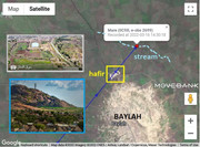
2019: Mare raised two chicks (nesting area: near Fruzenskoye, Pravdinsky District in Kaliningrad Oblast, RUSSIA)
Latvia: MARE, adult female
-
- Site Admin
- Posts: 14363
- Joined: 29 Sep 2021, 09:38
Re: Latvia: MARE, adult female
MARE https://goris.lv/mare-2017/
Hello everyone
previous data: viewtopic.php?p=1198#p1198
13.03 - 89 242 km, app: 2,7 km (24h), south from Bambasi, a town in western Ethiopia, Asosa Zone of the Benishangul-Gumuz Region of ETHIOPIA
new data
14.03 - 89 468 km, app: 210 km (24h), Abu Qudaf - in the region of Blue Nile. Blue Nile's capital Ad-Damazin is approximately 62 km away from Abu Qudaf (as the crow flies). The distance from Abu Qudaf to SUDAN's capital Khartoum is approximately 515 km (as the crow flies).
basic informations: viewtopic.php?p=1209#p1209
usually localisations are: L1 at 8.40, L2 at 10h, L3 at 11.30, L4 at 13h and L5 at 14.30
her localisation at 11.30 is already in Sudan, her today last know localisation is south from the Roseires Reservoir on the Blue Nile at Ad Damazin (just upstream of the town of Er Roseires), not far from Abu Qudaf (a hamlet)
https://en.wikipedia.org/wiki/Roseires_Dam
https://en.wikipedia.org/wiki/Blue_Nile
click for big pic
1/ situation - 2/ loc- L4 - L5
the dam area (in the time of construction)
more photos (also this) https://megaconstrucciones.net/en/roseires-dam/
on the googlemap is nothing like this (https://www.google.de/maps/place/11%C2% ... d34.739178)
-
- Site Admin
- Posts: 14363
- Joined: 29 Sep 2021, 09:38
Re: Latvia: MARE, adult female
MARE https://goris.lv/mare-2017/
March 15
Hello everyone
previous data: viewtopic.php?p=1210#p1210
14.03 - 89 468 km, app: 210 km (24h), Abu Qudaf - in the region of Blue Nile. Blue Nile's capital Ad-Damazin is approximately 62 km away from Abu Qudaf (as the crow flies). The distance from Abu Qudaf to Sudan's capital Khartoum is approximately 515 km (as the crow flies).
new data:
15.03 - 89 651 km, app: 136,9 km (24h), south from Qaddura - El Rahad, state of Gedaref, SUDAN
basic informations: viewtopic.php?p=1209#p1209
usually localisations are: L1 at 8.40, L2 at 10h, L3 at 11.30, L4 at 13h and L5 at 14.30
click for big pic
1/situation - 2/localisation at 14.30 (south from Qaddura)
3/mapbox (app) closer view - 4/ mapbox (app) wider view
-
- Site Admin
- Posts: 14363
- Joined: 29 Sep 2021, 09:38
Re: Latvia: MARE, adult female
MARE https://goris.lv/mare-2017/
March 16
Hello everyone
the map is working properly
previous data: viewtopic.php?p=1230#p1230
15.03 - 89 651 km, app: 136,9 km (24h), south from Qaddura - El Rahad, state of Gedaref, Sudan
new data:
16.03 - 89 739 km, app: 87 km (24h), to the north from the hamlet Baylah - Al Qadarif region, Gedaref State, SUDAN
basic informations: viewtopic.php?p=1209#p1209
usually localisations are: L1 at 8.40, L2 at 10h, L3 at 11.30, L4 at 13h and L5 at 14.30
click for big pic
1/situation - 2/localisation at 14.30
PHOTO of Baylah https://goo.gl/maps/KPSCXA1A7oZShSwc7, image capture Nov 2020
PHOTO - hafir (not that in Baylah, but not far) https://goo.gl/maps/jWL6bAeeX86Npvz77, image capture May 2020
information to hafir dams are in discussion thread: viewtopic.php?p=1237#p1237
3/ migrat. path - 4/ wide view
-
- Site Admin
- Posts: 14363
- Joined: 29 Sep 2021, 09:38
Re: Latvia: MARE, adult female
MARE https://goris.lv/mare-2017/
March 17
Hello everyone
today they aren't new data (yet) - last data: 16.03
edit (the last 2 week)
March 17
Hello everyone
today they aren't new data (yet) - last data: 16.03
edit (the last 2 week)
-
- Site Admin
- Posts: 14363
- Joined: 29 Sep 2021, 09:38
Re: Latvia: MARE, adult female
MARE https://goris.lv/mare-2017/
March 18
Hello everyone
today they aren't new data again - last data: 16.03 viewtopic.php?p=1236#p1236
March 18
Hello everyone
today they aren't new data again - last data: 16.03 viewtopic.php?p=1236#p1236
-
- Site Admin
- Posts: 14363
- Joined: 29 Sep 2021, 09:38
Re: Latvia: MARE, adult female
MARE https://goris.lv/mare-2017/
March 19
Hello everyone
Mare's transmitter sent data again
previous data: viewtopic.php?p=1236#p1236
16.03 - 89 739 km, app: 87 km (24h), to the north from the hamlet Baylah - Al Qadarif region, Gedaref State, SUDAN
new data:
19.03 - 90 239 km, app: 143,9 km (24h), to the east on the irrigated field not far from the University of Sheikh Abdullah al-Badri in Berber, River Nile state of northern SUDAN
- Berber is a town 50 kilometres north of Atbara, near the junction of the Atbara River and the Nile (https://en.wikipedia.org/wiki/Berber,_Sudan)
- the Atbara River joins the Nile at the city of Atbara, and is the last tributary of the Nile before it reaches the Mediterranean Sea (https://en.wikipedia.org/wiki/Atbarah_River)
- Mare reached this area year ago one week earlier
basic informations: viewtopic.php?p=1209#p1209
usually localisations are: L1 at 8.40, L2 at 10h, L3 at 11.30, L4 at 13h and L5 at 14.30
click for big pic
1/ situation - 2/ today path - 3/ localisation L5
PHOTO the irrigated fields there https://goo.gl/maps/T4znhDwm8sPXEUrJ7 , image capture Jul 2020
1/her exact GPS localisation (L5) and 2/ localisation in Sudan
-
- Site Admin
- Posts: 14363
- Joined: 29 Sep 2021, 09:38
Re: Latvia: MARE, adult female
MARE continuation
PHOTOs of the University of Sheikh Abdullah al-Badri in Berber https://www.google.com/maps/place/Sheik ... 5?hl=en-GB
PHOTO wider view on that area on the university webpage (eng) https://eaeu.edu.sd/blog/2021/02/25/edi ... s/?lang=en
PHOTOs (12.12.2009) - wider view on the confluence area (of the Atbara River and the Nile):
The Atbara River looking towards the confluence with the Nile https://pbase.com/bmcmorrow/image/120832102
Small park at the confluence of the Atbara River and the Nile https://pbase.com/bmcmorrow/image/120832105
Atbara River near the confluence with the Nile https://pbase.com/bmcmorrow/image/120832082
Making mud bricks on the banks of the Atbara River https://pbase.com/bmcmorrow/image/120832083
PHOTO Atbara river in Sudan - aerial view https://pbase.com/image/130664290
-
- Site Admin
- Posts: 14363
- Joined: 29 Sep 2021, 09:38
Re: Latvia: MARE, adult female
MARE https://goris.lv/mare-2017/
March 21
Hello everyone
Mare's transmitter don't sent data again - last data: 19.03 - 90 239 km
situation year ago:
2021-03-12 (81 769 km)
- localisation: SUDAN, Bayuda desert - on the left bank the river Nil, north-west from Atbara in River Nile State in northeastern Sudan (2022: norht-east from Atbara)
new data:
- 2021-03-19 ( 83 066 km)
- localisation: ETHIOPIA, Sinai Peninsula - South Governorate
maybe this year the new data will come after a week like last year - we have to wait patiently probably to 26.03
1/ localisations in Atbara area - 2/ update after week (2021)
-
- Site Admin
- Posts: 14363
- Joined: 29 Sep 2021, 09:38
Re: Latvia: MARE, adult female
MARE https://goris.lv/mare-2017/
March 22
Hello everyone
nice surprise - there are new data, Mare flew from Atbara to Hurghada
previous data: viewtopic.php?f=50&t=60&p=1260#p1260
19.03 - 90 239 km, app: 143,9 km (24h), to the east on the irrigated field not far from the University of Sheikh Abdullah al-Badri in Berber, River Nile state of northern SUDAN
new data:
22.03 - 91 188 km, app: 241,7 km (24h), to the west from the Mosque of Old Om Elhowaitat - El Qoseir (a city in eastern Egypt, located on the Red Sea coast), Red Sea Governorate, EGYPT (south from Safaga)
basic informations: viewtopic.php?p=1209#p1209
usually localisations are: L1 at 8.40, L2 at 10h, L3 at 11.30, L4 at 13h and L5 at 14.30
click for big pic
1/ situation + today path - 2/localisation L5 and photo - 3/ morning path (the Gulf of Suez - most probably)
PHOTO Mosque of Old Om Elhowaitat wider view https://goo.gl/maps/biSPmF21cSS9N73i8 image capture Aug 2019 (better view https://goo.gl/maps/bWhxpi9mdQZaGbwx7 image capture Dec 2013 - "Panorama over an abandoned ghost town in desert mountains")
exterior https://goo.gl/maps/ZFDMq9gCCBHWwsfv8 and the interior of this Mosque https://goo.gl/maps/MN64B8oKezmShD3S6 (image capture Dec 2013)
interesting reading (and photos) "Umm el Howeitat was born and grew to become one of the most important mining towns of phosphate in Egypt at this time." - https://scoopempire.com/photo-diary-ins ... host-city/