NURME - adult male whos territory is situated in west-central Estonia (we follow him the first season)
spring migration started: 23.03.2022 (most probably)
last autumn birdmap update: (06.10.2021) viewtopic.php?p=89#p89
the newest data before spring migration started: viewtopic.php?p=1334#p1334 (in preparation - done)
Estonia: NURME, adult male
-
marika.solo
- Site Admin
- Posts: 27926
- Joined: 29 Sep 2021, 09:38
Re: Estonia: NURME, adult male
NURME - http://birdmap.5dvision.ee/EN/2022/spri ... =0&speed=1
birdmap update
- Distance: 2208 km, Last data: 28.03.2022
- to the west from Luxor, Qena Governorate, EGYPT
more in the morning - done
birdmap update
- Distance: 2208 km, Last data: 28.03.2022
- to the west from Luxor, Qena Governorate, EGYPT
more in the morning - done
-
marika.solo
- Site Admin
- Posts: 27926
- Joined: 29 Sep 2021, 09:38
Re: Estonia: NURME, adult male
NURME - http://birdmap.5dvision.ee/EN/2022/spri ... =0&speed=1
previous data:
- Last data: 15.03.2022, Distance: 317 km
- ETHIOPIA, Amhara Region, North Gondar Zone
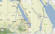
new data: plus 1891 km/13 days
- Last data: 28.03.2022, Distance: 2208 km
- to the west from Luxor, Qena Governorate, EGYPT
1/ situation in Africa with all 3 adult stork - 2/ Nurme on the way - 3/ detail/localisation
more maybe only in the evening
previous data:
- Last data: 15.03.2022, Distance: 317 km
- ETHIOPIA, Amhara Region, North Gondar Zone
new data: plus 1891 km/13 days
- Last data: 28.03.2022, Distance: 2208 km
- to the west from Luxor, Qena Governorate, EGYPT
1/ situation in Africa with all 3 adult stork - 2/ Nurme on the way - 3/ detail/localisation
more maybe only in the evening
-
marika.solo
- Site Admin
- Posts: 27926
- Joined: 29 Sep 2021, 09:38
Re: Estonia: NURME, adult male
we have thanks Madli: "Overview map - continuously updated" viewtopic.php?f=57&t=64
-
marika.solo
- Site Admin
- Posts: 27926
- Joined: 29 Sep 2021, 09:38
Re: Estonia: NURME, adult male
NURME - http://birdmap.5dvision.ee/EN/2022/spri ... =0&speed=1
April 02
Hello everyone
birdmap update
- Distance: 3331 km, Last data: 01.04.2022
- north LEBANON in the region of Baalbek-Hermel
more later - done
April 02
Hello everyone
birdmap update
- Distance: 3331 km, Last data: 01.04.2022
- north LEBANON in the region of Baalbek-Hermel
more later - done
-
marika.solo
- Site Admin
- Posts: 27926
- Joined: 29 Sep 2021, 09:38
Re: Estonia: NURME, adult male
NURME - http://birdmap.5dvision.ee/EN/2022/spri ... =0&speed=1
previous data:
- Last data: 28.03.2022, Distance: 2208 km
- to the west from Luxor, Qena Governorate, EGYPT
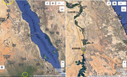
new data:
- Last data: 01.04.2022, Distance: 3331 km plus 1891 km/13 days
- to the north of Beit Hassan - a town in the region of Baalbek-Hermel (Governorate), LEBANON
1/ from Egypt to Lebanon - 2/ the newest known localisation/area
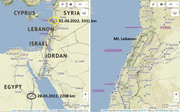
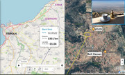
photo https://goo.gl/maps/C9YqnczGyTrTV6WJ7 Nov 2019
a closer look at the hills where he has the newest localisation (in fly?) https://mapio.net/images-p/42042259.jpg
previous data:
- Last data: 28.03.2022, Distance: 2208 km
- to the west from Luxor, Qena Governorate, EGYPT
new data:
- Last data: 01.04.2022, Distance: 3331 km plus 1891 km/13 days
- to the north of Beit Hassan - a town in the region of Baalbek-Hermel (Governorate), LEBANON
1/ from Egypt to Lebanon - 2/ the newest known localisation/area
photo https://goo.gl/maps/C9YqnczGyTrTV6WJ7 Nov 2019
a closer look at the hills where he has the newest localisation (in fly?) https://mapio.net/images-p/42042259.jpg
-
marika.solo
- Site Admin
- Posts: 27926
- Joined: 29 Sep 2021, 09:38
Re: Estonia: NURME, adult male
NURME - http://birdmap.5dvision.ee/EN/2022/spri ... =0&speed=1
April 04
Hello everyone
birdmap update
- Last data: 03.04.2022, Distance: 3905 km
- in the area the Kızılırmak also known as the Halys River, to the east from one quarry - to the NE from the village Kuruağıl, Kırşehir district/Kırşehir Province, central Anatolian region, TURKEY
more later - done
April 04
Hello everyone
birdmap update
- Last data: 03.04.2022, Distance: 3905 km
- in the area the Kızılırmak also known as the Halys River, to the east from one quarry - to the NE from the village Kuruağıl, Kırşehir district/Kırşehir Province, central Anatolian region, TURKEY
more later - done
-
marika.solo
- Site Admin
- Posts: 27926
- Joined: 29 Sep 2021, 09:38
Re: Estonia: NURME, adult male
NURME - http://birdmap.5dvision.ee/EN/2022/spri ... =0&speed=1
previous data: viewtopic.php?p=1400#p1400
- Last data: 01.04.2022, Distance: 3331 km
- to the north of Beit Hassan - a town in the region of Baalbek-Hermel (Governorate), LEBANON
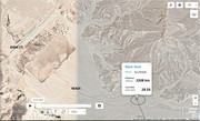
new data:
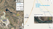
- Last data: 03.04.2022, Distance: 3905 km plus 574 km/2 days
- in the area the Kızılırmak also known as the Halys River, to the east from one quarry - to the NE from the village Kuruağıl, Kırşehir district/Kırşehir Province, central Anatolian region, TURKEY
The Kızılırmak (Turkish for "Red River"), also known as the Halys River and Alis, is the longest river entirely within Turkey. It is a source of hydroelectric power and is not used for navigation. (wiki) - see pic: https://en.wikipedia.org/wiki/K%C4%B1z% ... ak-map.jpg
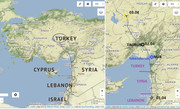
Nurme continued from Lebanon to Syria and flew over the Gulf of Alexandretta or İskenderun (Turkish: İskenderun Körfezi) to Turkey. The night spent north from Tümenli - village in Karaisalı District, Adana Province and the next day he crossed the Taurus Mt. and continued to the north-west (Eedi to SW).
1/ situation - 2/ view/map on his newest loc. - 3/ distance street view to his loc., resp. on the Kızılırmak River
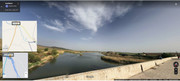
STREET VIEW https://goo.gl/maps/wxXwVXCqK32AUXT97 image capture May 2017
there Nurme flew to his newest location https://goo.gl/maps/4LyBKz8skXVLUREm6 image capture Apr 2015
more pic (the closest village Kuruağıl) https://goo.gl/maps/UUB52Lx29hm54AFF6 (https://www.google.com/maps/place/Kurua ... 6?hl=en-GB)
previous data: viewtopic.php?p=1400#p1400
- Last data: 01.04.2022, Distance: 3331 km
- to the north of Beit Hassan - a town in the region of Baalbek-Hermel (Governorate), LEBANON
new data:
- Last data: 03.04.2022, Distance: 3905 km plus 574 km/2 days
- in the area the Kızılırmak also known as the Halys River, to the east from one quarry - to the NE from the village Kuruağıl, Kırşehir district/Kırşehir Province, central Anatolian region, TURKEY
The Kızılırmak (Turkish for "Red River"), also known as the Halys River and Alis, is the longest river entirely within Turkey. It is a source of hydroelectric power and is not used for navigation. (wiki) - see pic: https://en.wikipedia.org/wiki/K%C4%B1z% ... ak-map.jpg
Nurme continued from Lebanon to Syria and flew over the Gulf of Alexandretta or İskenderun (Turkish: İskenderun Körfezi) to Turkey. The night spent north from Tümenli - village in Karaisalı District, Adana Province and the next day he crossed the Taurus Mt. and continued to the north-west (Eedi to SW).
1/ situation - 2/ view/map on his newest loc. - 3/ distance street view to his loc., resp. on the Kızılırmak River
STREET VIEW https://goo.gl/maps/wxXwVXCqK32AUXT97 image capture May 2017
there Nurme flew to his newest location https://goo.gl/maps/4LyBKz8skXVLUREm6 image capture Apr 2015
more pic (the closest village Kuruağıl) https://goo.gl/maps/UUB52Lx29hm54AFF6 (https://www.google.com/maps/place/Kurua ... 6?hl=en-GB)
-
marika.solo
- Site Admin
- Posts: 27926
- Joined: 29 Sep 2021, 09:38
Re: Estonia: NURME, adult male
NURME - http://birdmap.5dvision.ee/EN/2022/spri ... =0&speed=1
April 6
birdmap update (late evening)
NURME
- Last data: 06.04.2022, Distance: 4767 km
- BULGARIA, pond east from Malkata Mera/Малката Мера, Shumen municipality, Shumen Province
more morning - done
April 6
birdmap update (late evening)
NURME
- Last data: 06.04.2022, Distance: 4767 km
- BULGARIA, pond east from Malkata Mera/Малката Мера, Shumen municipality, Shumen Province
more morning - done
-
marika.solo
- Site Admin
- Posts: 27926
- Joined: 29 Sep 2021, 09:38
Re: Estonia: NURME, adult male
NURME http://birdmap.5dvision.ee/EN/2022/spri ... =0&speed=1
April 7
previous data: viewtopic.php?p=1427#p1427
- Last data: 03.04.2022, Distance: 3905 km
- in the area the Kızılırmak also known as the Halys River, to the east from one quarry - to the NE from the village Kuruağıl, Kırşehir district/Kırşehir Province, central Anatolian region, TURKEY
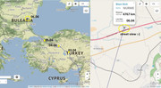
new data: plus 862 km/3 days
- Last data: 06.04.2022, Distance: 4767 km
- BULGARIA, pond east from Malkata Mera/Малката Мера, Shumen municipality, Shumen Province
Nurme "crossed" the Sea of Marmara above Istanbul (his path-line) and continued in fly to Bulgaria. Newest data are after crossing the Balkan Mt. near Malkata Mera in one pond area.
1/ situation/change - 2/ street view on his newest loc.
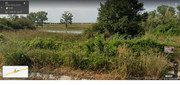
2/ STREET VIEW https://goo.gl/maps/CmDiR5qDrNLrvGyL6 image capture Aug 2021
- wider view on that area from above https://goo.gl/maps/x55zZ1Sbvfgmkf2TA and this one https://goo.gl/maps/4MSR2b9Ldf6VdU7fA
above the Bosporus Strait
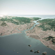
photo: https://www.odysseytraveller.com/articl ... ea-turkey/
reading (info, photos, video) https://www.imtilak.net/en/articles/ist ... rus-bridge
his path-line is here (Istanbul/Bosporus) https://goo.gl/maps/Bu4msLy5gPWMXhFG7image capture Dec 2014
April 7
previous data: viewtopic.php?p=1427#p1427
- Last data: 03.04.2022, Distance: 3905 km
- in the area the Kızılırmak also known as the Halys River, to the east from one quarry - to the NE from the village Kuruağıl, Kırşehir district/Kırşehir Province, central Anatolian region, TURKEY
new data: plus 862 km/3 days
- Last data: 06.04.2022, Distance: 4767 km
- BULGARIA, pond east from Malkata Mera/Малката Мера, Shumen municipality, Shumen Province
Nurme "crossed" the Sea of Marmara above Istanbul (his path-line) and continued in fly to Bulgaria. Newest data are after crossing the Balkan Mt. near Malkata Mera in one pond area.
1/ situation/change - 2/ street view on his newest loc.
2/ STREET VIEW https://goo.gl/maps/CmDiR5qDrNLrvGyL6 image capture Aug 2021
- wider view on that area from above https://goo.gl/maps/x55zZ1Sbvfgmkf2TA and this one https://goo.gl/maps/4MSR2b9Ldf6VdU7fA
above the Bosporus Strait
photo: https://www.odysseytraveller.com/articl ... ea-turkey/
reading (info, photos, video) https://www.imtilak.net/en/articles/ist ... rus-bridge
his path-line is here (Istanbul/Bosporus) https://goo.gl/maps/Bu4msLy5gPWMXhFG7image capture Dec 2014