the autumn birdmap starts with data from August 15
The spring/summer migration stops in mid-August and the autumn/winter migration continues from the following day, the 15th = the bird map is set for autumn/winter migration and the new distance measurement starts from 15.08. However, the birdmap is sometimes ready a week or two later.
in this thread we follow young adult female named KUREMARI (hatched 2021) from Latvia (we follow Kuremari's 2nd autumn-winter migration with trasmitter)
This stork with Latvian rings was caught by Urmas and equipped with transmitter in Haanja NP (https://kaitsealad.ee/en/protected-area ... ature-park) and appeared to the birdmap.
KUREMARI is an interesting choice of name. In direct translation it means Stork's berry and it is a folk name for cranberries. (info by our Madli - thx!)
KUREMARI colour ring number:OXUJ - 4 CY
(CY = calendar year; birds are aged as the number of calendar years they have lived in, with the year they were born in as the 1st calendar year and increasing past every January 1st.)
data source: https://birdmap.5dvision.ee/EN/2024/aut ... =0&speed=1
birdmap-description:
Probably a female stork, caught on July 24, 2023 in Võru County. It turned out to be a ringed bird from Latvia. According to Maris Strazds, it was ringed as a nestling in July 2021, 40 km northeast of Riga. She was seen on May 26, 2023 in Latvian black stork webcam. Probably did not breed in 2023, but was often with a year-younger Black Stork. She did not rush to start her autumn migration, but made several more stops in Estonia, Latvia and Belarus. Longer stop over in Romania, Danube flood plain.
-----
"Nesting 2024": Kuremari explored Latvia
"Nesting 2023": Probably did not breed in 2023, but was often with a year-younger Black Stork. (birdmap info)
Kuremari, young female (data on the birdmap)
-
marika.solo
- Site Admin
- Posts: 27926
- Joined: 29 Sep 2021, 09:38
-
marika.solo
- Site Admin
- Posts: 27926
- Joined: 29 Sep 2021, 09:38
Re: Kuremari, young female (data on the birdmap)
Autumn-winter migration 2024-2025
(2023 birdmap started on 26.08)
birdmap started on - first data for Kuremari on
0/ departure/migration started on 13.08 (?) (Lithuania - Labanoras Regional Park)
(2023: from Latvia on 12.08)
- Belarus (13.08), Ukraine (14.08, 15.08), Moldova (16.08), border area Moldova-Romania (17.08)
1/ stopover place/s from 18.08 to 21.09
(2023: from 22.08 to 04.10 )
arrival https://www.ciconianigra.sk/viewtopic.p ... 493#p39493 - departure https://www.ciconianigra.sk/viewtopic.p ... 888#p39888
- Romania: Danube meadows and the fields with melioration canals
- Turkey/SE Europe (22.09)
2/ crossing the Sea of Marmara 23.09 via Bosporus https://www.ciconianigra.sk/viewtopic.p ... 908#p39908
(2023 on 07.10 via Bosporus Strait)
- Turkey/West Asia (23.09, 24., 25.09)
3/ crossing the the Gulf of Iskenderun 25.09 via the Gulf https://www.ciconianigra.sk/viewtopic.p ... 967#p39967
(2023 on 10.10 along/near the northern shore of the Gulf )
- Syria (26.09, no data this day) - Israel (27.09 - 05.10)
stopover (?) Beit She'an valley (arrival 27.09 https://www.ciconianigra.sk/viewtopic.p ... 068#p40068 - departure 05.10 https://www.ciconianigra.sk/viewtopic.p ... 5&start=50
- Egypt, Sinay Governorate (05.10)
NO new data till now
Last data: https://www.ciconianigra.sk/viewtopic.p ... 165#p40165
- 05.10.2024, EGYPT, Sinay: Al Kuntillah - a village in North Sinai Governorate
4/ crossing the Gulf of Suez:
(2023 on 22.10, near El Tor - Gebel El Zeit area)
(2023 Last update on 23.10.2023, EGYPT: Edfu - a city in Edfu Municipality of Aswan Governorate/Upper Egypt)
new data on 29.03.2024 from AFRICA, EGYPT: Wadi el Gemal Reserve/National Park - Marsa Alam, Red Sea Governorate
5/ arrival to wintering destination:
(2023 on )
continuation SPRING MIGRATION 2025 https://www.ciconianigra.sk/viewtopic.p ... 830#p40830
-----
Autumn-winter migration 2023/24 - overview: https://www.ciconianigra.sk/viewtopic.php?f=95&t=144
-
marika.solo
- Site Admin
- Posts: 27926
- Joined: 29 Sep 2021, 09:38
Re: Kuremari, young female (data on the birdmap)
Probably a female stork, caught on July 24, 2023 in Võru County. It turned out to be a ringed bird from Latvia. According to Maris Strazds, it was ringed as a nestling in July 2021, 40 km northeast of Riga. She was seen on May 26, 2023 in Latvian black stork webcam. (birdmap info)
Kuremari was in the Latvian nest camera for a moment in the spring (confirmed by Dr. M.Strazds).
Here is info about this stork (and video) in our forum (we don't know if this female moved near the nest also the previous days): 26.05.2023 https://www.ciconianigra.sk/viewtopic.p ... 352#p16352:
info by Dr. Maris Strazds in Latvian Forum:
Unfortunately, I can't be sure confirm it would be a female. According to measurements during ringing, it was male - but it's not 100%, there are about 10-15% errors for gender determined in this way. DNA testing has not yet been done. The bird was the youngest of three chicks in a nest near Pabažie (67.15 km from this nest). The bird is ringed 2021 at about 44 days old on July 4, the bird's age today is 734 days (calendar year 3), it is DEFINITELY a juvenile ("teenager") bird, which "gets to know the living space".
(26.05.2023 https://forums.dabasdati.lv/viewtopic.p ... 51#p369351)
video of this visit by Vērotāja - thank you!
-
marika.solo
- Site Admin
- Posts: 27926
- Joined: 29 Sep 2021, 09:38
Re: Kuremari, young female (data on the birdmap)
autumn migration path
from Estonia: Haanja Landscape Conservation Area / Haanja looduspark to Inderta woreda of the Tigray Region in Ethiopia
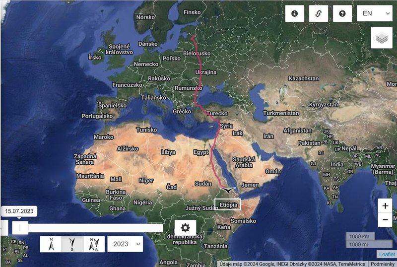
birdmap info: She did not rush to start her autumn migration, but made several more stops in Estonia, Latvia and Belarus. Longer stop over in Romania, Danube flood plain.
stopover site from 22.08 to 04.10.2023
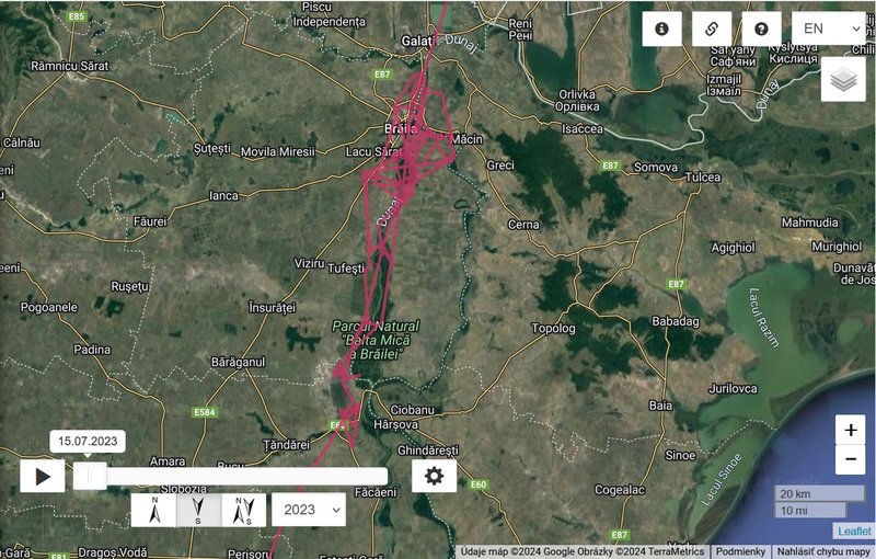
ROMANIA, Parcul Natural Balta Mică a Brăilei - Balta Mică Natural Park of Braila:
is located in the South – East of Romania and occupies a segment of 62 km of the Lower Danube, between the Giurgeni-Vadu Oii road bridge (km 237, on the Danube, upstream) and the municipality of Brăila (km 175 downstream ).
It is a Wetland of International Importance (declared in June 2001) and since 2008 has received the status of Natura 2000 Site both as a Site of Community Importance and as a Special Area of Avifauna Protection.
PN-BmB preserves on an area of 241 square km, the last complexes of aquatic and terrestrial ecosystems in flood-free regime that remained after the dam of Brăila and Ialomița ponds (former Inner Delta – 2,413 square km ).
PN-BmB consists of a chain of 7 large Danube islands (with areas between 242 ha – Harapu island and 9,727 ha – Insula Mică a Brăila island), separated by 7 arms of the Danube totaling a length of 149 km watercourse. The 7 large islands consist of 4,466 ha of aquatic habitats (grouped in 52 inland lakes) and 10,709 ha of terrestrial habitats
(https://bmb.ro/index.php/en/home/ ... more videos- on of them:
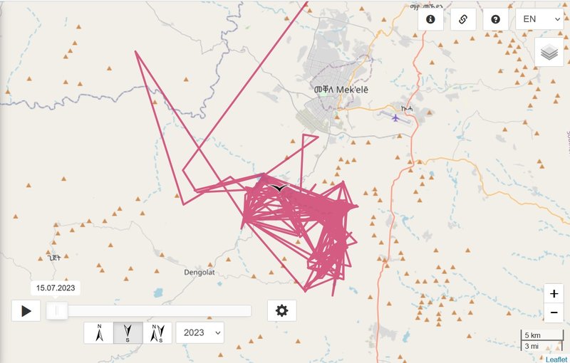
wintering site
Gereb Segen - a reservoir located in the Inderta woreda of the Tigray Region in Ethiopia and May Gabat river - a river of northern Ethiopia. Rising in the mountains of Inderta (2,233 metres above sea level), it flows westward to Giba River, which empties finally in the Tekezé River. The Gereb Segen reservoir has been built on this river in 2016, mainly for providing Mekelle with potable water.(https://en.wikipedia.org/wiki/May_Gabat and https://en.wikipedia.org/wiki/Gereb_Segen_(May_Gabat)
more info and PHOTOS of this area are here https://www.ciconianigra.sk/viewtopic.p ... 523#p39523
from Estonia: Haanja Landscape Conservation Area / Haanja looduspark to Inderta woreda of the Tigray Region in Ethiopia
birdmap info: She did not rush to start her autumn migration, but made several more stops in Estonia, Latvia and Belarus. Longer stop over in Romania, Danube flood plain.
stopover site from 22.08 to 04.10.2023
ROMANIA, Parcul Natural Balta Mică a Brăilei - Balta Mică Natural Park of Braila:
is located in the South – East of Romania and occupies a segment of 62 km of the Lower Danube, between the Giurgeni-Vadu Oii road bridge (km 237, on the Danube, upstream) and the municipality of Brăila (km 175 downstream ).
It is a Wetland of International Importance (declared in June 2001) and since 2008 has received the status of Natura 2000 Site both as a Site of Community Importance and as a Special Area of Avifauna Protection.
PN-BmB preserves on an area of 241 square km, the last complexes of aquatic and terrestrial ecosystems in flood-free regime that remained after the dam of Brăila and Ialomița ponds (former Inner Delta – 2,413 square km ).
PN-BmB consists of a chain of 7 large Danube islands (with areas between 242 ha – Harapu island and 9,727 ha – Insula Mică a Brăila island), separated by 7 arms of the Danube totaling a length of 149 km watercourse. The 7 large islands consist of 4,466 ha of aquatic habitats (grouped in 52 inland lakes) and 10,709 ha of terrestrial habitats
(https://bmb.ro/index.php/en/home/ ... more videos- on of them:
wintering site
Gereb Segen - a reservoir located in the Inderta woreda of the Tigray Region in Ethiopia and May Gabat river - a river of northern Ethiopia. Rising in the mountains of Inderta (2,233 metres above sea level), it flows westward to Giba River, which empties finally in the Tekezé River. The Gereb Segen reservoir has been built on this river in 2016, mainly for providing Mekelle with potable water.(https://en.wikipedia.org/wiki/May_Gabat and https://en.wikipedia.org/wiki/Gereb_Segen_(May_Gabat)
more info and PHOTOS of this area are here https://www.ciconianigra.sk/viewtopic.p ... 523#p39523
-
marika.solo
- Site Admin
- Posts: 27926
- Joined: 29 Sep 2021, 09:38
Re: Kuremari, young female (data on the birdmap)
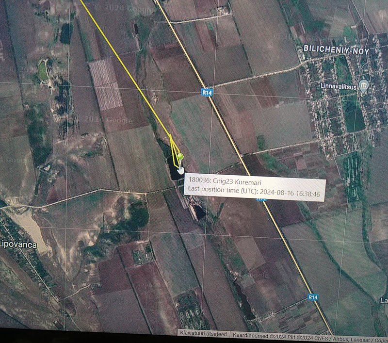
August 16 data
Hello everyone
"data source": our Madli - big thx!
Kuremari's 5 days
FROM:
- LATVIA
TO:
- MOLDOVA: Lipovanca - a village (Bilicenii Noi commune) in Sîngerei District
new data: 16.08.2024 (at 16.38)
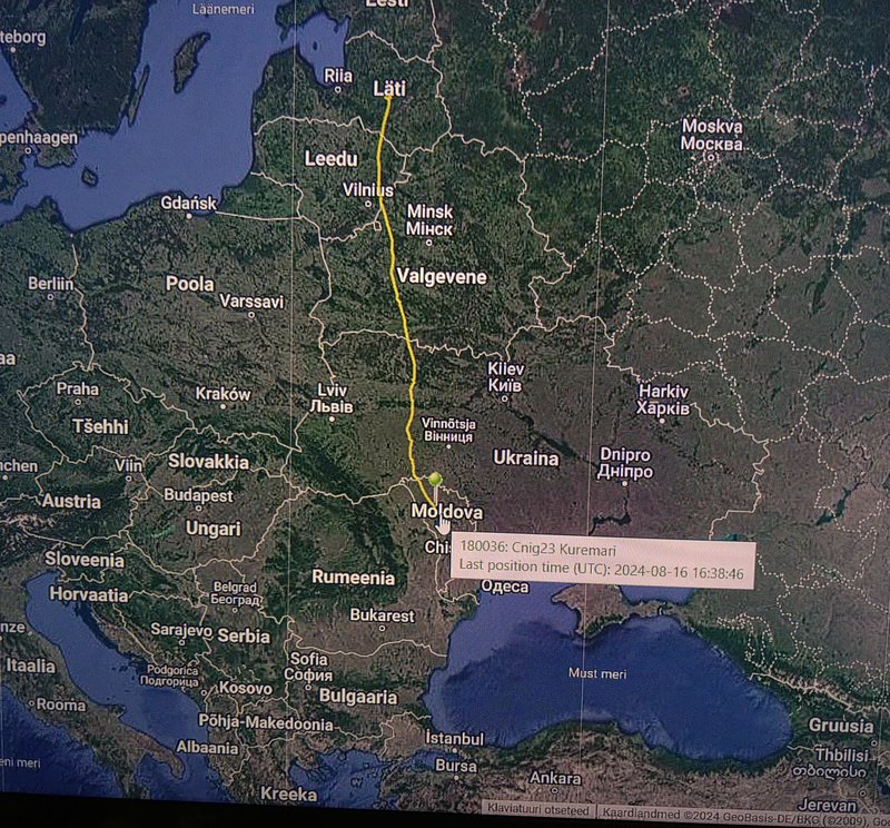
some kind of ponds (reservoirs)
Hello everyone
"data source": our Madli - big thx!
Kuremari's 5 days
FROM:
- LATVIA
TO:
- MOLDOVA: Lipovanca - a village (Bilicenii Noi commune) in Sîngerei District
new data: 16.08.2024 (at 16.38)
some kind of ponds (reservoirs)
-
marika.solo
- Site Admin
- Posts: 27926
- Joined: 29 Sep 2021, 09:38
Re: Kuremari, young female (data on the birdmap)
- Belarus (13.08), Ukraine (14.08, 15.08), Moldova (16.08), border area Moldova-Romania (17.08)
Kuremari reached her stop-over place in Romania. (Stopover sites are places for birds to rest, refuel, and seek shelter during their bi-annual migration.)
2023: from 22.08 to 04.10
2024: from 18.08 to
Photos, videos and information are already in the previous year thread - from here https://www.ciconianigra.sk/viewtopic.p ... 579#p23579
enjoy!
-
marika.solo
- Site Admin
- Posts: 27926
- Joined: 29 Sep 2021, 09:38
Re: Kuremari, young female (data on the birdmap)
August 18 - 20
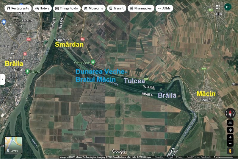
Kuremari explored/checked the area to the east from Brăila (a city in Muntenia, eastern Romania, a port on the Danube and the capital of Brăila County. It is the area of:
The Old Danube river arm/Măcin arm (Dunarea Veche-Bratul Măcin):
is Important Bird Area - IBA (http://datazone.birdlife.org/site/facts ... ba-romania) and Ramsar Site (https://rsis.ramsar.org/ris/2116): The site is part of the Danube meadow and is situated in an important migration corridor, providing breeding, resting and feeding shelter for many bird species. The landscape is characterized by lakes between sand dunes, marshes, shrub wetlands, fishponds, islands, canals and drainage channels all very rich in biodiversity. Belong to Natura 2000 sites (https://eunis.eea.europa.eu/sites/ROSPA0040)
there (in the video) we see the whole area where Kuremari is moving these days
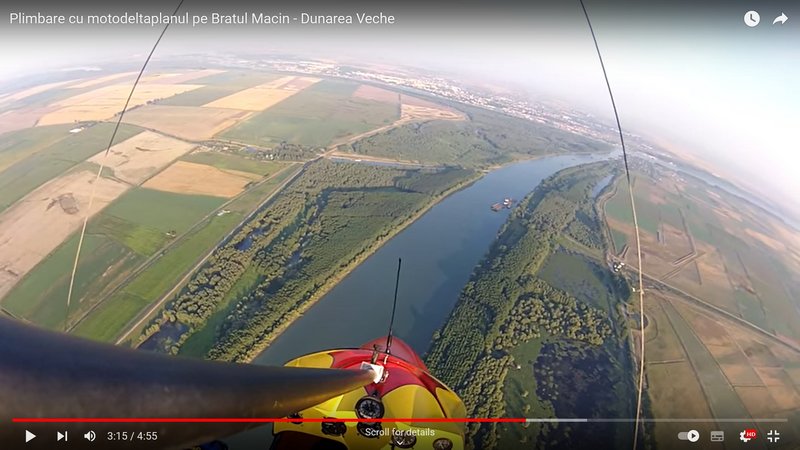
pic form VIDEO: Plimbare cu motodeltaplanul pe Bratul Macin - Dunarea Veche (Ride with the hang glider on Bratul Macin - Old Danube) https://youtu.be/YKkO_efg3k4 uploaded on 29 Jul 2015 by Cristian Deceanu
first posted there (24.08.2023) https://www.ciconianigra.sk/viewtopic.p ... 678#p23678
Kuremari explored/checked the area to the east from Brăila (a city in Muntenia, eastern Romania, a port on the Danube and the capital of Brăila County. It is the area of:
The Old Danube river arm/Măcin arm (Dunarea Veche-Bratul Măcin):
is Important Bird Area - IBA (http://datazone.birdlife.org/site/facts ... ba-romania) and Ramsar Site (https://rsis.ramsar.org/ris/2116): The site is part of the Danube meadow and is situated in an important migration corridor, providing breeding, resting and feeding shelter for many bird species. The landscape is characterized by lakes between sand dunes, marshes, shrub wetlands, fishponds, islands, canals and drainage channels all very rich in biodiversity. Belong to Natura 2000 sites (https://eunis.eea.europa.eu/sites/ROSPA0040)
there (in the video) we see the whole area where Kuremari is moving these days
pic form VIDEO: Plimbare cu motodeltaplanul pe Bratul Macin - Dunarea Veche (Ride with the hang glider on Bratul Macin - Old Danube) https://youtu.be/YKkO_efg3k4 uploaded on 29 Jul 2015 by Cristian Deceanu
first posted there (24.08.2023) https://www.ciconianigra.sk/viewtopic.p ... 678#p23678
-
marika.solo
- Site Admin
- Posts: 27926
- Joined: 29 Sep 2021, 09:38
Re: Kuremari, young female (data on the birdmap)
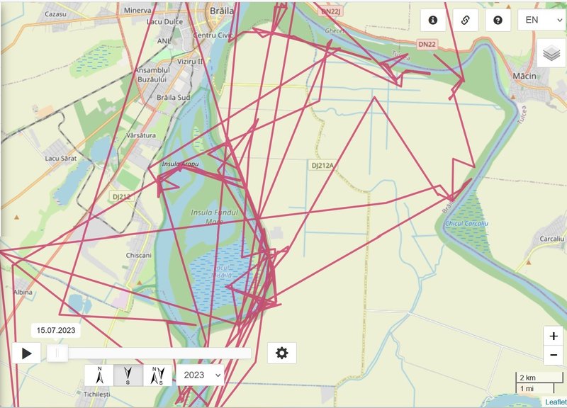
August 21, 22
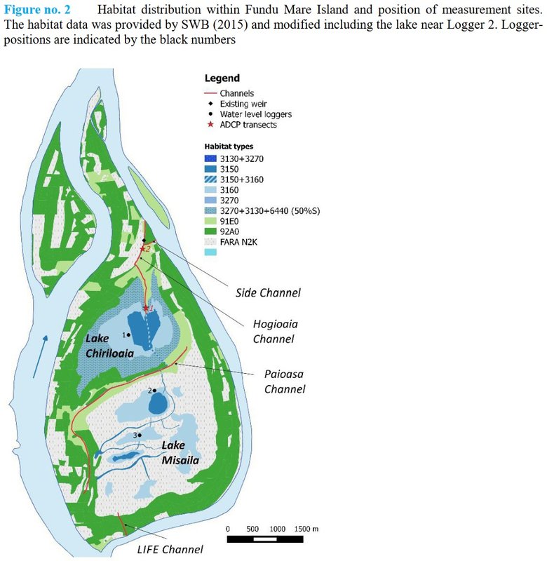
Kuremari explored/checked the area to the south from Brăila (a city in Muntenia, eastern Romania, a port on the Danube and the capital of Brăila County). It is the area of the Balta Mică a Brăilei Natural Park. Her localisation is now on the southern part of the Island of Fundu Mare - the Lake Misăila.
Kuremari in this area in season 2023
-
marika.solo
- Site Admin
- Posts: 27926
- Joined: 29 Sep 2021, 09:38
Re: Kuremari, young female (data on the birdmap)
FUNDU MARE Island
first in previous season https://www.ciconianigra.sk/viewtopic.p ... 770#p24770
Fundu Mare Island has an area of 1,899 ha, of which 965 are forest and 934 ha are freshwater (lakes Chiriloaia, Stan, Misăilă and Bratusca). The special conservation area of 857 ha in the south of the island and the colony of cormorants, herons and egrets at Chiriloaia, of ornithological interest, and the white-tailed eagle nests in the south of the island are of particular interest from a tourist point of view.
The mixed colony of herons, egrets and cormorants, located only 4 km from Brăila, was particularly appreciated by the governor of Sicily, Dr. Salvatore Cuffaro (2010), and by Prof. H. Alvaro from the University of Madrid.
(source: http://wikimapia.org/34070023/ro/Insula-Fundu-Mare)
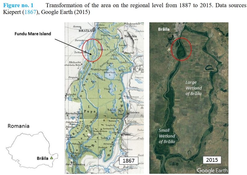
(source: Onea, Nicolae & Zinke, Peggy & Ionescu, Tudor & Gheorghe, Daniela & Foldvik, Anders & Gjershaug, Jan & Brückner, Muriel & Aberle, Jochen & Nedelcut, Florin. (2017). HYDROLOGICAL AND ECOLOGICAL INVESTIGATIONS FOR THE RESTORATION OF THE ECOSYSTEM COMPLEX OF FUNDU MARE ISLAND. Journal of Wetlands Biodiversity. 7. 131-161.)
first in previous season https://www.ciconianigra.sk/viewtopic.p ... 770#p24770
Fundu Mare Island has an area of 1,899 ha, of which 965 are forest and 934 ha are freshwater (lakes Chiriloaia, Stan, Misăilă and Bratusca). The special conservation area of 857 ha in the south of the island and the colony of cormorants, herons and egrets at Chiriloaia, of ornithological interest, and the white-tailed eagle nests in the south of the island are of particular interest from a tourist point of view.
The mixed colony of herons, egrets and cormorants, located only 4 km from Brăila, was particularly appreciated by the governor of Sicily, Dr. Salvatore Cuffaro (2010), and by Prof. H. Alvaro from the University of Madrid.
(source: http://wikimapia.org/34070023/ro/Insula-Fundu-Mare)
(source: Onea, Nicolae & Zinke, Peggy & Ionescu, Tudor & Gheorghe, Daniela & Foldvik, Anders & Gjershaug, Jan & Brückner, Muriel & Aberle, Jochen & Nedelcut, Florin. (2017). HYDROLOGICAL AND ECOLOGICAL INVESTIGATIONS FOR THE RESTORATION OF THE ECOSYSTEM COMPLEX OF FUNDU MARE ISLAND. Journal of Wetlands Biodiversity. 7. 131-161.)
-
marika.solo
- Site Admin
- Posts: 27926
- Joined: 29 Sep 2021, 09:38
Re: Kuremari, young female (data on the birdmap)
Parcul Natural "Balta Mică a Brăila (PN-BmB) / Balta Mică a Brăilei Natural Park
some info and video already here: viewtopic.php?p=38903#p38903
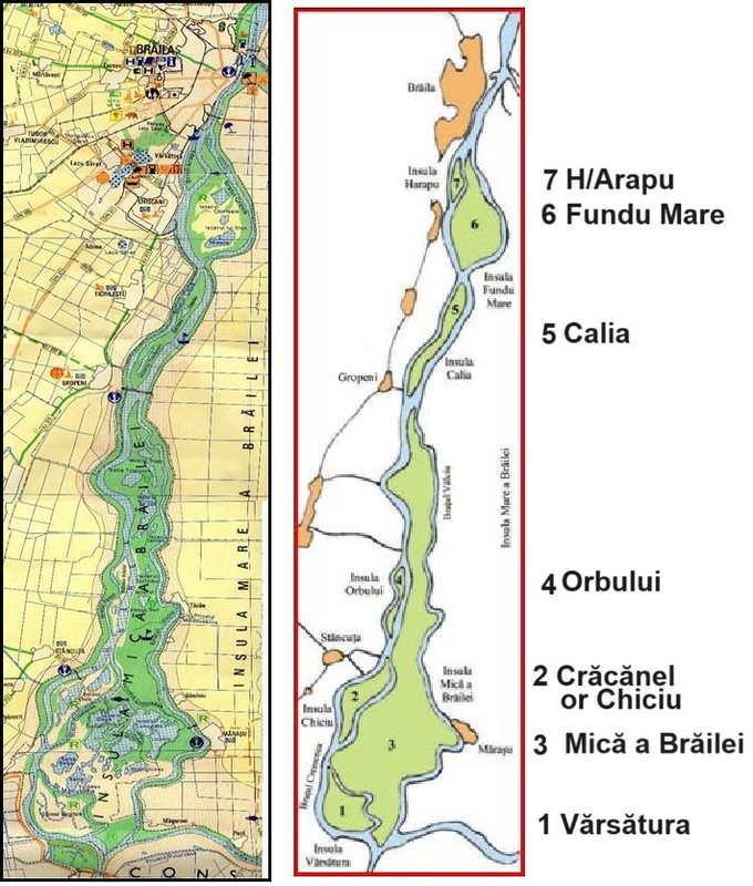
The park consists of a chain of 7 large Danube islands (with areas between 242 ha – Harapu island and 9,727 ha – Insula Mică a Brăila island), separated by 7 arms of the Danube totaling a length of 149 km watercourse. The 7 large islands consist of 4,466 ha of aquatic habitats (grouped in 52 inland lakes) and 10,709 ha of terrestrial habitats.
(Insula/romanian = Island): 1/ Insula Vărsătura, 2/ Insula Mică a Brăilei (Small Island of Brăila), 3/ Insula Crăcănel (Trăsura sau Chiciu), 4/ Insula (Chiciul) Orbului, 5/ Insula Lupului (Calia sau Caleia), 6/ Insula Fundu Mare, 7/ Insula (H)Arapu.
The Small Island of Brăila is part of the Balta Mică Natural Park, nicknamed the "second Delta" of the country. In addition to this, it was also registered in Natura 2000 Site and Ramsar Site.
It is one of the most representative destinations of the county, being among the visitors' favourites. Although Balta Brăilei has a total of seven islands, it is also the most important from a scientific point of view, due to its Delta-like ecosystem.
(https://planiada.ro/destinatii/braila/i ... railei-386)
The Small Island of Braila, declared a natural reserve in 1994, is a group of wetlands in the Lower Danube area. This is one of the rare areas bordering the river which has preserved its natural hydrological conditions and which contains a representative sample of habitats, which are characteristic of floodplains as well as an ancient inland delta. Comprising seven small islands with a total surface area of 17 .586 hectares, the area is a site of major interest for birds, both for the quality of the habitats present and for its location on the migration routes midway between the nesting areas in the north of Europe and the wintering areas in Africa.
Small Island of Braila is a component of Lower Danube System, a key complex of wetland ecosystems ... Small Island of Braila,
represents a real internal delta ... Located along the Danube River between km 175 (marika: the municipality of Brăila - km 175 downstream) and 237 (marika: the Giurgeni-Vadu Oii road bridge - km 237 on the Danube upstream) in the Braila County.
The nearest large town, Braila is located in the northern part of the Small Island of Braila. With a total length of 61-km, represent the remained naturally flooded area after the building of a dike (151-km length) that changed the most part (75%) of the former "Braila Marsh".
On the remained flooded area of about 23000 ha, the most important area is called "The Small Island of Braila" (17000 ha), delimited by secondary arm (Valciu, Manusoaia, Calia, Cravia) and navigable arm of the Danube river, situated in the Braila county.
(https://rsis.ramsar.org/RISapp/files/RI ... 074RIS.pdf)
https://www.qreferat.com/referate/geogr ... -BR718.php
some info and video already here: viewtopic.php?p=38903#p38903
The park consists of a chain of 7 large Danube islands (with areas between 242 ha – Harapu island and 9,727 ha – Insula Mică a Brăila island), separated by 7 arms of the Danube totaling a length of 149 km watercourse. The 7 large islands consist of 4,466 ha of aquatic habitats (grouped in 52 inland lakes) and 10,709 ha of terrestrial habitats.
(Insula/romanian = Island): 1/ Insula Vărsătura, 2/ Insula Mică a Brăilei (Small Island of Brăila), 3/ Insula Crăcănel (Trăsura sau Chiciu), 4/ Insula (Chiciul) Orbului, 5/ Insula Lupului (Calia sau Caleia), 6/ Insula Fundu Mare, 7/ Insula (H)Arapu.
The Small Island of Brăila is part of the Balta Mică Natural Park, nicknamed the "second Delta" of the country. In addition to this, it was also registered in Natura 2000 Site and Ramsar Site.
It is one of the most representative destinations of the county, being among the visitors' favourites. Although Balta Brăilei has a total of seven islands, it is also the most important from a scientific point of view, due to its Delta-like ecosystem.
(https://planiada.ro/destinatii/braila/i ... railei-386)
The Small Island of Braila, declared a natural reserve in 1994, is a group of wetlands in the Lower Danube area. This is one of the rare areas bordering the river which has preserved its natural hydrological conditions and which contains a representative sample of habitats, which are characteristic of floodplains as well as an ancient inland delta. Comprising seven small islands with a total surface area of 17 .586 hectares, the area is a site of major interest for birds, both for the quality of the habitats present and for its location on the migration routes midway between the nesting areas in the north of Europe and the wintering areas in Africa.
Small Island of Braila is a component of Lower Danube System, a key complex of wetland ecosystems ... Small Island of Braila,
represents a real internal delta ... Located along the Danube River between km 175 (marika: the municipality of Brăila - km 175 downstream) and 237 (marika: the Giurgeni-Vadu Oii road bridge - km 237 on the Danube upstream) in the Braila County.
The nearest large town, Braila is located in the northern part of the Small Island of Braila. With a total length of 61-km, represent the remained naturally flooded area after the building of a dike (151-km length) that changed the most part (75%) of the former "Braila Marsh".
On the remained flooded area of about 23000 ha, the most important area is called "The Small Island of Braila" (17000 ha), delimited by secondary arm (Valciu, Manusoaia, Calia, Cravia) and navigable arm of the Danube river, situated in the Braila county.
(https://rsis.ramsar.org/RISapp/files/RI ... 074RIS.pdf)
https://www.qreferat.com/referate/geogr ... -BR718.php