Kergu (adult male, Pärnu County)

marika.solo
Site Admin
Posts: 17977
Joined: 29 Sep 2021, 09:38

Re: Kergu (adult male, Pärnu County)

Post by marika.solo »

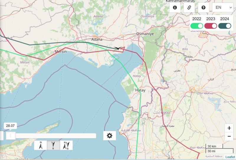
Kergu crossed the Taurus Mt. - today is before him the Gulf of İskenderun and the north-south leading Nur Mountains.
Image

Image
marika.solo
Site Admin
Posts: 17977
Joined: 29 Sep 2021, 09:38

Re: Kergu (adult male, Pärnu County)

Post by marika.solo »

birdmap update for Kergu too (data 21.09) :-) already in Israel (north from Karameh Dam)

regular post follows soon
marika.solo
Site Admin
Posts: 17977
Joined: 29 Sep 2021, 09:38

Re: Kergu (adult male, Pärnu County)

Post by marika.solo »

previous update 19.09 (late evening) / data 19.09 https://www.ciconianigra.sk/viewtopic.p ... 841#p39841)
next update 25.09/data for Kergu 24.09 https://www.ciconianigra.sk/viewtopic.p ... 933#p39933


September 22 (data 21.09 - maybe early morning update for Kergu)
Hello everyone :-)

Previous data:
- 19.09.2024, 4846 km (+ 312 km - longer distance again)
- Turkey: Zeytinbeli - Yumurtalık district of Adana province

NEW data:
- 21.09.2024, 6329 km (+ 1 483 ?! km - in 2 days; fake lines to Ankara airport and back)
- ISRAEL (West Bank): Wadi Al-Fara’a (north from Karameh Dam)

Image

Image
marika.solo
Site Admin
Posts: 17977
Joined: 29 Sep 2021, 09:38

Re: Kergu (adult male, Pärnu County)

Post by marika.solo »

Kergu arrived there in season 2023 on 05.10 (this season 2 weeks earlier) https://www.ciconianigra.sk/viewtopic.p ... 130#p25130

Wadi al-Far'a or Tirzah Stream
https://en.wikipedia.org/wiki/Wadi_al-Far%27a_(river)

Wadi al-Far'a (Arabic: وادي الفارعه) or Tirzah Stream (Hebrew: נַחַל תִּרְצָה, romanized: Nahal Tirzah) is a stream in the northern West Bank that empties into the Jordan River south of Damia Bridge. It is the largest stream in the West Bank. Wadi al-Far'a is located in the rugged area of the West Bank and cuts east through the Jordan Valley, passing through the Palestinian village of Wadi al-Far'a. The Tirzah Reservoir is used to collect the floodwater of Wadi al-Far'a before it flows into the Jordan River.

https://en.wikipedia.org/wiki/Wadi_al-F ... rchaeology
https://madeinholyland.net/wadi-al-fara-river/

Image

Image

Tirzah reservoir ("View from the Mustra lookout" - more pic: https://commons.wikimedia.org/wiki/Cate ... _reservoir)

Image
By Dr. Avishai Teicher Pikiwiki Israel, CC BY 2.5, https://commons.wikimedia.org/w/index.p ... d=25601192

btw. Sartaba Lokout - Mustra = Srdobh Iskenderun (Alexandrium) - to the north, NW from the Wadi Al-Fara’s dam
marika.solo
Site Admin
Posts: 17977
Joined: 29 Sep 2021, 09:38

Re: Kergu (adult male, Pärnu County)

Post by marika.solo »

moved from the previous post

Tirtsa Reservoir (מאגר תירצה) (photos googlemaps - also white stork there)https://maps.app.goo.gl/avdUWwxtQxMnktWq6

btw. (GT) it is necessary to call the tourism department of the Jordan Valley Regional Council since the gate in the "system" is locked; since the reservoir is east of the upper perimeter fence, it is not possible (for now) to enter the Nahal Tirza reserve without permission from the army (https://amudanan.co.il/#!wiki=P559933)

excursion to this area - observing birds (photos)
https://www.facebook.com/GreenValleyFes ... u3x5Gb2Txl

360 view https://www.facebook.com/GreenValleyFes ... X2ycLFeul
GT 360°
The Tirzah Reservoir in the Jordan Valley is on the eastern side of the border fence.
To travel in this area between the fence and the physical border that is on the banks of the Jordan River, you need to get a special permit from the IDF.
But during the Fridays of March, access to the place is possible for everyone.
So if you are traveling in the Bekaa region, it is very worthwhile to go on a trip.
The Tirzah Reservoir consists of three tiered dams designed to store water for the irrigation of agriculture in the area.
There is an observatory from where you can observe the reservoirs and dams. 200 meters away you can climb to a point with a panoramic view of the three reservoirs
The Jordan Valley is known for the quality of the Majhol date, and the State of Israel is the leading country in the export of the coveted fruit.

PHOTOS of this area (Tirtsa reservoir)
https://www.lavi-natif.co.il/%D7%9E%D7% ... %A6%D7%94/
marika.solo
Site Admin
Posts: 17977
Joined: 29 Sep 2021, 09:38

Re: Kergu (adult male, Pärnu County)

Post by marika.solo »

September 22

NO new data for Kergu

Last data: https://www.ciconianigra.sk/viewtopic.p ... 882#p39882
- 21.09.2024, 6329 km (+ 1 483 ?! km - in 2 days; fake lines to Ankara airport and back)
- ISRAEL (West Bank): Wadi Al-Fara’a (north from Karameh Dam)
marika.solo
Site Admin
Posts: 17977
Joined: 29 Sep 2021, 09:38

Re: Kergu (adult male, Pärnu County)

Post by marika.solo »

September 24

NO new data for Kergu

Last data: https://www.ciconianigra.sk/viewtopic.p ... 882#p39882
- 21.09.2024, 6329 km (+ 1 483 ?! km - in 2 days; fake lines to Ankara airport and back)
- ISRAEL (West Bank): Wadi Al-Fara’a (north from Karameh Dam)

btw. on the map of Polish storks, I saw fake lines in the area where he flew on (hopefully, happily)
marika.solo
Site Admin
Posts: 17977
Joined: 29 Sep 2021, 09:38

Re: Kergu (adult male, Pärnu County)

Post by marika.solo »

previous update 22.09 / data 21.09 https://www.ciconianigra.sk/viewtopic.p ... 882#p39882
next update: NO NEW DATA


September 25 (update, data for Kergu 24.09)
Hello everyone :-)

Previous data:
- 21.09.2024, 6329 km (+ 1 483 ?! km - in 2 days; fake lines to Ankara airport and back)
- ISRAEL (West Bank): Wadi Al-Fara’a (north from Karameh Dam)

NEW data:
- 24 (!).09.2024, 6623 km (+ 294 km - in 2 days)
- AFRICA: Halaib Triangle - in 1994 the Egyptian military moved to take control of the area as a part of Red Sea Governorate


Image

Image

Image
marika.solo
Site Admin
Posts: 17977
Joined: 29 Sep 2021, 09:38

Re: Kergu (adult male, Pärnu County)

Post by marika.solo »

crossing the Gulf of Suez (storks are flying to Africa usually in the area of the El Tor)

Image

PHOTO
view to the arrival area from the Gulf
(click) https://maps.app.goo.gl/tsQDhG7yJHvgpcMf8 + https://maps.app.goo.gl/dcWTKYe9rUXKQvMk9 Jabal Zayt
Wadi Dar Al Zaraey, Ras Ghareb, Red Sea Governorate by Saar Dvir Photo - Jan 2017

the arrival area - to the north of Gabal El-Zeit (more in this post https://www.ciconianigra.sk/viewtopic.p ... 352#p10352)
- the Gebel al-Zeit is Important Bird Area (IBA)
- new wind farm "Gabal El Zeit" is one of the world’s largest electricity-generating plants in terms of area, the number of turbines and capacities generated from the station; - The station contains the system of monitoring migratory birds, through the radar to stop the turbines when the birds fly then reoperate them, a system used for the first time in the world.

PHOTO Gebel al-Zeit wind farm
(click) https://www.afrik21.africa/wp-content/u ... 00x400.jpg
(source: https://www.afrik21.africa/en/egypt-acw ... wind-farm/)

PHOTO Gebel al-Zeit from about 1982
(click)https://www.reddit.com/r/geology/commen ... /#lightbox
(source: https://www.reddit.com/r/geology/commen ... ?rdt=39997)
marika.solo
Site Admin
Posts: 17977
Joined: 29 Sep 2021, 09:38

Re: Kergu (adult male, Pärnu County)

Post by marika.solo »

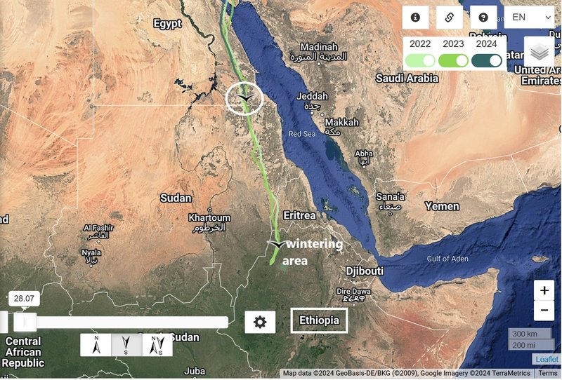
next migration path to his wintering place - probably today Kergu will reach it

Image
Post Reply

Return to “Estonia”