A large freshwater marsh situated at the southern edge of the Konya plain, fed by surface run-off, stream and spring water. Areas of reedbed (Phragmites) are interspersed with patches of open water. The IBA includes Süleymanhacý, a groundwater-fed saline lake, 6 km south of the main wetland. Extensive areas of steppe and arable land surround the IBA. Reed-cutting is the main economic activity (`Other' land-use).
This is an important site for breeding waterbirds, numbers of which have fallen considerably in recent years as a result of low water-levels. Pelecanus crispus is thought to have bred in small numbers until 1990 and Chettusia leucura bred until 1986. (https://datazone.birdlife.org/site/fact ... C3%BCrkiye)
Hotamış Lake (sometimes called swamp) is located 50 km southeast of Konya between Çumra and Karapınar districts. The lake, which fills a large part of the region, has occasionally caused floods and destroyed many houses in the surrounding villages. When it became a serious threat to the surrounding settlements, DSİ began to build earthen banks around it in 1970. These banks are still in place. However, the lake's water, which began to recede in 1974, has completely dried up over time. Before the Beyşehir-Çumra irrigation networks were established, it was storing the waters of the Çarşamba Stream and had not been used for a long time. However, with the implementation of the Blue Tunnel project, it gained importance again and work has been started and is continuing to use it as storage. (http://www.kop.gov.tr/upload/dokumanlar/32.pdf
Hotamış Lake 12/1985 ---------- Hotamış Storage 4/2018 (clickable)
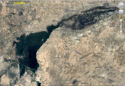
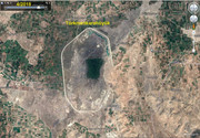
from lake to storage
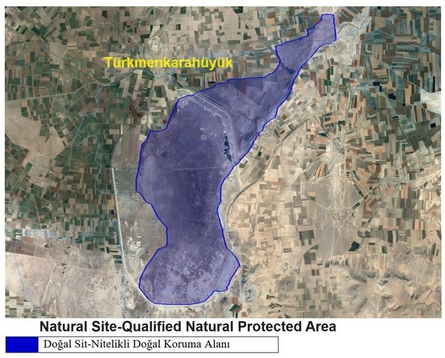
https://webdosya.csb.gov.tr/db/konya/duyurular/konya_hotam-s_golu_word_tesc0l_0lani-20190802114128.pdf
10.10.2022 A comparison between yesterday and today: Land cover change in Hotamış Rushy https://fragilelandscapes.net/a-compari ... mis-rushy/ (PHOTOS)
https://dogadernegi.org/wp-content/uplo ... kitabi.pdf (Doga is the partner of BirdLife International in Turkey)